Villard-Saint-Christophe | |
|---|---|
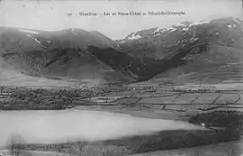 Villard-Saint-Cristophe and the Pierre-Châtel Lake at the start of the 20th century | |
.svg.png.webp) Coat of arms | |
Location of Villard-Saint-Christophe | |
 Villard-Saint-Christophe 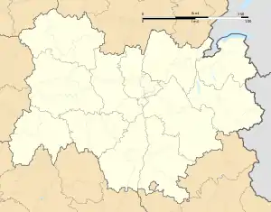 Villard-Saint-Christophe | |
| Coordinates: 44°58′47″N 5°48′23″E / 44.9797°N 5.8064°E | |
| Country | France |
| Region | Auvergne-Rhône-Alpes |
| Department | Isère |
| Arrondissement | Grenoble |
| Canton | Matheysine-Trièves |
| Intercommunality | La Matheysine |
| Government | |
| • Mayor (2020–2026) | Serge Mora[1] |
| Area 1 | 14 km2 (5 sq mi) |
| Population | 400 |
| • Density | 29/km2 (74/sq mi) |
| Time zone | UTC+01:00 (CET) |
| • Summer (DST) | UTC+02:00 (CEST) |
| INSEE/Postal code | 38552 /38119 |
| Elevation | 940–2,176 m (3,084–7,139 ft) (avg. 1,071 m or 3,514 ft) |
| 1 French Land Register data, which excludes lakes, ponds, glaciers > 1 km2 (0.386 sq mi or 247 acres) and river estuaries. | |
Villard-Saint-Christophe (French pronunciation: [vilaʁ sɛ̃ kʁistɔf]) is a commune in the Isère department in southeastern France.[3]
Population
| Year | Pop. | ±% p.a. |
|---|---|---|
| 1968 | 229 | — |
| 1975 | 199 | −1.99% |
| 1982 | 216 | +1.18% |
| 1990 | 226 | +0.57% |
| 1999 | 272 | +2.08% |
| 2009 | 362 | +2.90% |
| 2014 | 410 | +2.52% |
| 2020 | 401 | −0.37% |
| Source: INSEE[4] | ||
See also
References
- ↑ "Répertoire national des élus: les maires". data.gouv.fr, Plateforme ouverte des données publiques françaises (in French). 2 December 2020.
- ↑ "Populations légales 2021". The National Institute of Statistics and Economic Studies. 28 December 2023.
- ↑ INSEE commune file
- ↑ Population en historique depuis 1968, INSEE
Wikimedia Commons has media related to Villard-Saint-Christophe.
This article is issued from Wikipedia. The text is licensed under Creative Commons - Attribution - Sharealike. Additional terms may apply for the media files.