Kortesjärvi | |
|---|---|
Former municipality | |
| Kortesjärven kunta Kortesjärvi kommun | |
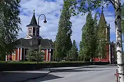 Kortesjärvi Church | |
 Coat of arms | |
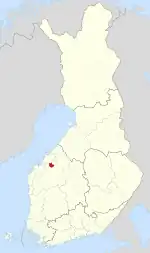 Location of Kortesjärvi in Finland | |
| Coordinates: 63°18′N 023°09.5′E / 63.300°N 23.1583°E | |
| Country | Finland |
| Region | Southern Ostrobothnia |
| Sub-region | Järviseutu sub-region |
| Founded | 1865 |
| Consolidated | 2009 |
| Area | |
| • Total | 333.51 km2 (128.77 sq mi) |
| • Land | 323.7 km2 (125.0 sq mi) |
| • Water | 9.81 km2 (3.79 sq mi) |
| Population (2008-12-31)[2] | |
| • Total | 2,275 |
| • Density | 6.8/km2 (18/sq mi) |
| Time zone | UTC+2 (EET) |
| • Summer (DST) | UTC+3 (EEST) |
Kortesjärvi is a former municipality of Finland. It was consolidated, together with Alahärmä and Ylihärmä, to Kauhava on 1 January 2009.
It is located in the province of Western Finland and is part of the Southern Ostrobothnia region. The municipality had a population of 2,275 (as of 31 December 2008)[2] and covered a land area of 323.70 square kilometres (124.98 sq mi).[1] The population density was 9.81 inhabitants per square kilometre (25.4/sq mi).
The municipality was unilingually Finnish.
References
- 1 2 "Area by municipality as of 1 January 2008" (PDF) (in Finnish and Swedish). Land Survey of Finland. Retrieved 20 January 2011.
- 1 2 "Population by municipality as of 31 December 2008". Population Information System (in Finnish and Swedish). Population Register Center of Finland. Archived from the original on 2011-07-20. Retrieved 20 January 2011.
External links
![]() Media related to Kortesjärvi at Wikimedia Commons
Media related to Kortesjärvi at Wikimedia Commons
| Municipalities |  | |
|---|---|---|
| Former municipalities |
| |
This article is issued from Wikipedia. The text is licensed under Creative Commons - Attribution - Sharealike. Additional terms may apply for the media files.