Isojoki
Storå | |
|---|---|
Municipality | |
| Isojoen kunta Storå kommun | |
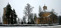 Isojoki church and bell tower | |
 Coat of arms | |
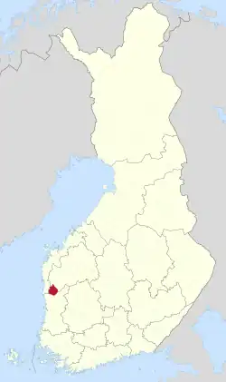 Location of Isojoki in Finland | |
| Coordinates: 62°06′50″N 21°57′30″E / 62.11389°N 21.95833°E | |
| Country | |
| Region | South Ostrobothnia |
| Sub-region | Suupohja sub-region |
| Charter | 1855 |
| Government | |
| • Municipal manager | Juha Herrala |
| Area (2018-01-01)[1] | |
| • Total | 647.43 km2 (249.97 sq mi) |
| • Land | 642.4 km2 (248.0 sq mi) |
| • Water | 5.05 km2 (1.95 sq mi) |
| • Rank | 134th largest in Finland |
| Population (2023-09-30)[2] | |
| • Total | 1,828 |
| • Rank | 265th largest in Finland |
| • Density | 2.85/km2 (7.4/sq mi) |
| Population by native language | |
| • Finnish | 95.5% (official) |
| • Swedish | 0.9% |
| • Others | 3.7% |
| Population by age | |
| • 0 to 14 | 11.3% |
| • 15 to 64 | 55.1% |
| • 65 or older | 33.7% |
| Time zone | UTC+02:00 (EET) |
| • Summer (DST) | UTC+03:00 (EEST) |
| Website | www.isojoki.fi |
Isojoki (Swedish: Storå; lit. "Big River") is a municipality of Finland. It is part of the South Ostrobothnia region. The city of Pori is located 83 kilometres (52 mi) south of Isojoki. The population of Isojoki is 1,828 (30 September 2023)[2] and the municipality covers an area of 642.4 km2 (248.0 sq mi) of which 5.05 km2 (1.95 sq mi) is inland water (1 January 2018).[1] The population density is 2.85/km2 (7.4/sq mi). The municipality is unilingually Finnish and neighbour municipalities are Honkajoki, Karijoki, Kauhajoki, Kristinestad, Merikarvia and Siikainen.
Although the area isn't very high, one of the highest hills of southern Finland is located here (Lauhanvuori). Many Finns from this area immigrated to Minnesota, in the USA, as well as Michigan.
Industry: Wood, potato, machinery.
Tourism: Lauhanvuori National Park (hotel, viewtower, big smoke sauna, historical nature with many relics from ice-age)
Nature: Mostly Forest, swamp and agriculture
References
- 1 2 "Area of Finnish Municipalities 1.1.2018" (PDF). National Land Survey of Finland. Retrieved 30 January 2018.
- 1 2 "Preliminary population statistics 2023, September". StatFin. Statistics Finland. Retrieved 26 October 2023.
- ↑ "Demographic Structure by area as of 31 December 2022". Statistics Finland's PX-Web databases. Statistics Finland. Retrieved 6 September 2023.
- ↑ "Population according to age (1-year) and sex by area and the regional division of each statistical reference year, 2003–2020". StatFin. Statistics Finland. Retrieved 2 May 2021.
External links
![]() Media related to Isojoki at Wikimedia Commons
Media related to Isojoki at Wikimedia Commons
- Municipality of Isojoki – Official website
Places adjacent to Isojoki | ||||||||||||||||
|---|---|---|---|---|---|---|---|---|---|---|---|---|---|---|---|---|
| ||||||||||||||||
| Municipalities |  | |
|---|---|---|
| Former municipalities |
| |