Jombang Regency
Kabupaten Jombang ꦏꦧꦸꦥꦠꦺꦤ꧀ꦗꦺꦴꦩ꧀ꦧꦁ | |
|---|---|
.jpg.webp) | |
 Coat of arms | |
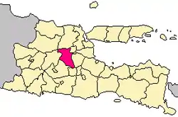 Location within East Java | |
| Coordinates: 7°28′S 112°14′E / 7.467°S 112.233°E | |
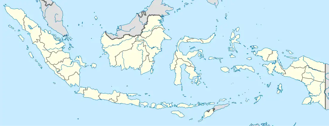
| Country | |
| Province | East Java |
| Capital | Jombang |
| Government | |
| • Regent | Mundjidah Wahab |
| • Vice Regent | vacant |
| Area | |
| • Total | 1,159.50 km2 (447.69 sq mi) |
| Population (mid 2022 estimate)[1] | |
| • Total | 1,335,972 |
| • Density | 1,200/km2 (3,000/sq mi) |
| Time zone | UTC+7 (IWST) |
| Area code | (+62) 321 |
| Website | jombangkab |

Jombang Regency (Indonesian: Kabupaten Jombang; Javanese: ꦏꦧꦸꦥꦠꦺꦤ꧀ꦗꦺꦴꦩ꧀ꦧꦁ) is a regency of East Java, Indonesia, situated to the southwest of Surabaya. The capital of the regency is the town of Jombang. The regency has an area of 1,159.48 km2 and a population of 1,202,407 at the 2010 census[2] and 1,318,062 at the 2020 census;[3] the official estimate as of mid-2022 was 1,335,972.[1] It became a regency in 1910. It was the birthplace of Abdurrahman Wahid, the 4th president of Indonesia.
Administrative districts
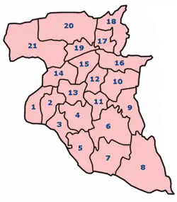
The regency is divided into twenty-one districts (kecamatan), tabulated below with their areas and population totals from the 2010 census[2] and the 2020 census,[3] together with the official estimates as of mid-2022.[1] The table also includes the locations of the district administrative centres, the number of administrative villages in each district (comprising 302 rural desa and 4 urban kelurahan - the latter all in Jombang (town) District), and its postal codes.
| Kode Wilayah | Name of District (kecamatan) | No. on map | Area in km2 | Pop'n census 2010 | Pop'n census 2020 | Pop'n estimate mid 2022 | Admin centre | No. of villages | Post codes |
|---|---|---|---|---|---|---|---|---|---|
| 35.17.18 | Bandarkedungmulyo | 1 | 32.50 | 43,193 | 49,959 | 51,160 | Banjarsari | 11 | 61462 |
| 35.17.01 | Perak | 2 | 29.05 | 50,876 | 55,975 | 56,769 | Perak | 13 | 61461 |
| 35.17.02 | Gudo | 3 | 34.39 | 50,471 | 55,997 | 56,883 | Gudo | 18 | 61463 |
| 35.17.08 | Diwek | 4 | 47.70 | 100,969 | 110,495 | 111,946 | Diwek | 20 | 61471 |
| 35.17.03 | Ngoro | 5 | 49.86 | 68,863 | 77,814 | 79,326 | Ngoro | 13 | 61473 |
| 35.17.07 | Mojowarno | 6 | 78.62 | 85,619 | 95,660 | 97,306 | Mojowarno | 19 | 61475 |
| 35.17.04 | Bareng | 7 | 94.27 | 49,470 | 56,539 | 57,765 | Bareng | 13 | 61474 |
| 35.17.05 | Wonosalam | 8 | 121.63 | 30,609 | 33,520 | 33,965 | Wonosalam | 9 | 61476 |
| 35.17.06 | Mojoagung | 9 | 60.18 | 73,004 | 81,051 | 82,345 | Gambiran | 18 | 61482 |
| 35.17.11 | Sumobito | 10 | 47.64 | 77,039 | 86,385 | 87,933 | Sumobito | 21 | 61483 |
| 35.17.19 | Jogoroto | 11 | 28.28 | 62,943 | 70,760 | 72,063 | Jogoroto | 11 | 61485 |
| 35.17.10 | Peterongan | 12 | 29.47 | 63,784 | 67,822 | 68,331 | Peterongan | 14 | 61481 |
| 35.17.09 | Jombang (town) | 13 | 36.40 | 137,233 | 139,831 | 139,722 | Jombatan | 20 (a) | 61411 - 61419 |
| 35.17.20 | Megaluh | 14 | 28.41 | 36,507 | 39,725 | 40,202 | Megaluh | 13 | 61457 |
| 35.17.13 | Tembelang | 15 | 32.94 | 49,371 | 54,891 | 55,782 | Pesantren | 15 | 61452 |
| 35.17.12 | Kesamben | 16 | 51.72 | 59,990 | 66,861 | 67,979 | Kesamben | 14 | 61484 |
| 35.17.17 | Kudu | 17 | 77.75 | 28,239 | 31,513 | 32,048 | Randuwatang | 11 | 61454 |
| 35.17.21 | Ngusikan | 18 | 34.96 | 20,928 | 22,793 | 23,071 | Ngusikan | 11 | 61450 |
| 35.17.14 | Ploso | 19 | 25.96 | 38,792 | 41,727 | 42,194 | Ploso | 13 | 61453 |
| 35.17.16 | Kabuh | 20 | 97.35 | 39,099 | 41,311 | 41,570 | Karangpaku | 16 | 61455 |
| 35.17.15 | Plandaan | 21 | 120.40 | 35,408 | 37,383 | 37,612 | Bangsri | 13 | 61456 |
| Totals | 1,159.50 | 1,202,407 | 1,318,062 | 1,335,972 | Jombang | 306 |
Note: (a) comprising 4 urban kelurahan (Jombatan, Jelakombo, Kaliwungu and Kepanjen) and 16 desa.
Climate
| Climate data for Jombang Regency | |||||||||||||
|---|---|---|---|---|---|---|---|---|---|---|---|---|---|
| Month | Jan | Feb | Mar | Apr | May | Jun | Jul | Aug | Sep | Oct | Nov | Dec | Year |
| Mean daily maximum °C (°F) | 33 (91) |
32 (90) |
33 (91) |
32 (90) |
31 (88) |
31 (88) |
30 (86) |
31 (88) |
32 (90) |
33 (91) |
35 (95) |
33 (91) |
32.2 (90.0) |
| Daily mean °C (°F) | 29 (84) |
28 (82) |
29 (84) |
28 (82) |
27 (81) |
27 (81) |
27 (81) |
27 (81) |
27 (81) |
28 (82) |
30 (86) |
29 (84) |
28 (82) |
| Mean daily minimum °C (°F) | 25 (77) |
25 (77) |
25 (77) |
25 (77) |
24 (75) |
24 (75) |
23 (73) |
23 (73) |
22 (72) |
24 (75) |
26 (79) |
25 (77) |
24.3 (75.7) |
| Average rainfall mm (inches) | 223 (8.8) |
221 (8.7) |
198 (7.8) |
237 (9.3) |
147 (5.8) |
181 (7.1) |
37 (1.5) |
20 (0.8) |
5 (0.2) |
29 (1.1) |
80 (3.1) |
280 (11.0) |
138.2 (5.44) |
| Average rainy days | 15 | 10 | 10 | 8 | 7 | 7 | 4 | 0 | 0 | 1 | 8 | 14 | 84 |
| Average relative humidity (%) | 71 | 79.78 | 78.32 | 82.83 | 74.16 | 69.7 | 66.61 | 68.03 | 64.23 | 64.22 | 64.3 | 72.8 | 71.3 |
| Source 1: "Weather Forecast & Reports - Long Range & Local | Wunderground | Weather Underground". www.wunderground.com. Retrieved 2016-04-12. | |||||||||||||
| Source 2: "Badan Pusat Statistik Kabupaten Jombang". jombangkab.bps.go.id. Archived from the original on 2016-04-23. Retrieved 2016-04-12. | |||||||||||||
| Month | Jan | Feb | Mar | Apr | May | Jun | Jul | Aug | Sep | Oct | Nov | Dec | Year |
| Maximum wind speed (km/h) | 58 | 69 | 60 | 48 | 45 | 29 | 60 | 63 | 182 | 138 | 29 | 40 | 68.42 |
| Average wind speed (km/h) | 45 | 48 | 45 | 48 | 42 | 11 | 14 | 14 | 14 | 15 | 11 | 11 | 26.5 |
| Minimum Wind Speed (km/h) | 26 | 29 | 37 | 48 | 40 | 0 | 0 | 0 | 0 | 0 | 0 | 0 | 15 |
| Minimum humidity (%) | 55 | 57.89 | 59.48 | 62.67 | 56.58 | 53.03 | 49.16 | 47.77 | 41.07 | 39.06 | 40.47 | 48.93 | 50.92 |
References
External links
- (in Indonesian) Official site