Aubure | |
|---|---|
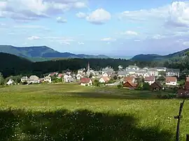 A general view of Aubure | |
.svg.png.webp) Coat of arms | |
Location of Aubure | |
 Aubure 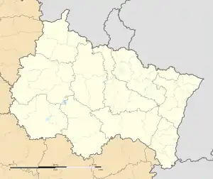 Aubure | |
| Coordinates: 48°11′53″N 7°13′19″E / 48.1981°N 7.2219°E | |
| Country | France |
| Region | Grand Est |
| Department | Haut-Rhin |
| Arrondissement | Colmar-Ribeauvillé |
| Canton | Sainte-Marie-aux-Mines |
| Intercommunality | CC Pays Ribeauvillé |
| Government | |
| • Mayor (2020–2026) | Marie-Paule Gay[1] |
| Area 1 | 4.9 km2 (1.9 sq mi) |
| Population | 360 |
| • Density | 73/km2 (190/sq mi) |
| Time zone | UTC+01:00 (CET) |
| • Summer (DST) | UTC+02:00 (CEST) |
| INSEE/Postal code | 68014 /68150 |
| Elevation | 727–1,144 m (2,385–3,753 ft) (avg. 800 m or 2,600 ft) |
| 1 French Land Register data, which excludes lakes, ponds, glaciers > 1 km2 (0.386 sq mi or 247 acres) and river estuaries. | |
Aubure (French pronunciation: [obyʁ] ⓘ; German: Altweier; Alsatian: Àltwihr) is a commune in the Haut-Rhin department in Grand Est in north-eastern France.[3]
See also
References
- ↑ "Répertoire national des élus: les maires". data.gouv.fr, Plateforme ouverte des données publiques françaises (in French). 2 December 2020.
- ↑ "Populations légales 2021". The National Institute of Statistics and Economic Studies. 28 December 2023.
- ↑ INSEE commune file
Wikimedia Commons has media related to Aubure.
This article is issued from Wikipedia. The text is licensed under Creative Commons - Attribution - Sharealike. Additional terms may apply for the media files.