| Yam-Alin | |
|---|---|
| Ям-Алинь | |
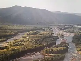
 View of the valley of the Nimelen | |
| Highest point | |
| Peak | Gorod-Makit |
| Elevation | 2,298 m (7,539 ft) |
| Coordinates | 52°57′07″N 134°39′26″E / 52.95194°N 134.65722°E[1] |
| Dimensions | |
| Length | 180 km (110 mi) S/N |
| Width | 40 km (25 mi) E/W |
| Geography | |
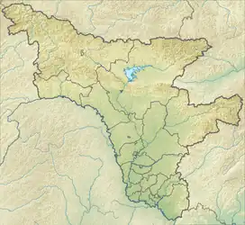
 Location in Amur Oblast | |
| Country | Russia |
| Federal subject | |
| Range coordinates | 53°15′N 134°45′E / 53.250°N 134.750°E |
| Geology | |
| Orogeny | Alpine orogeny |
| Age of rock | Permian |
| Type of rock | Volcanic rock, granite and crystalline schist |
| Climbing | |
| Easiest route | From Ekimchan |
The Yam-Alin (Russian: Ям-Алинь) is a mountain range in Amur Oblast and Khabarovsk Krai, Russian Far East.[2]
History
The range is located in a remote area and was unexplored until mid 19th century. Between 1849 and 1853, a large Russian military expedition led by Nikolai Khristoforovich Akhte operated in the Russian Far East. The German surveyor of the Russian service Ludwig Schwarz was assigned to it as an astronomer. Together with topographers Stepan Vasilievich Krutiv and Alexei Argunov, as well as geologist Nikolay Gavrilovich Meglitsky, the Yam-Alin range area was studied and topographically surveyed in detail. Based on their measurements, the first reliable map of Yam-Alin was drawn in 1851.[4]
Geography
The Yam-Alin and the Dusse-Alin to the south of it are northern prolongations of the Bureya Range. Its mountains display alpine relief and stretch for about 180 kilometres (110 mi).[5] The highest point is Gorod Makit with a height of 2,298 metres (7,539 ft).[6] To the southwest of the range rises the Ezop Range. In the north it connects with the southern end of the Taikan Range and to the northwest the Selemdzha Range stretches westwards.[2]
Hydrography
The range forms the watershed between the rivers of the Selemdzha and Amgun basins. Some of the right tributaries of the Selemzha, such as the Takh-Urak, Kumusun and Selitkan, have their sources in the western slopes of the range. On the eastern there are the sources of a few left tributaries of the Amgun, such as the Kerby and Nimelen, as well as the Assyni (Ассыни), a tributary of the Tugur and the Munikan, a tributary of the Konin —a tributary of the Tugur.[5][7][8]
Flora
The lower slopes of the range are covered with coniferous forests up to altitudes of 1,500 metres (4,900 ft), followed by thickets of dwarf cedar and mountain tundra at higher elevations.[5]
See also
References
- ↑ GeoHack - Gorod-Makit
- 1 2 Google Earth
- ↑ Geological scheme of the Ezop and Yam-Alin volcanic zones
- ↑ Агте, Николай Христофорович - ИРКИПЕДИЯ
- 1 2 3 Ям-Алинь — Great Soviet Encyclopedia : (in 30 vols.) - Ch. ed. A.M. Prokhorov. - 3rd ed. - M .: Soviet Encyclopedia, 1969-1978.
- ↑ Topographic map N-53; M 1: 1,000,00
- ↑ "Река АМГУНЬ in the State Water Register of Russia". textual.ru (in Russian).
- ↑ "Река КЕРБИ in the State Water Register of Russia". textual.ru (in Russian).