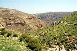
Wadi Khureitun or Nahal Tekoa is a wadi in a deep ravine in the Judaean Desert in the West Bank, west of the Dead Sea, springing near Tekoa.
Name
The Hebrew name, Nahal Tekoa ("Tekoa Stream"), and the English name used in some Christian contexts, Tekoa Valley, is derived from the ancient Judahite town of Tekoa.
The Arabic name, Wadi Khureitun, comes from the early Christian hermit, Saint Chariton the Confessor, who founded his third lavra in this valley.[1]
Description, history, archaeology
A hiking path on the west of the wadi passes a number of prehistoric caves on its way south to the Chariton Monastery ruins.
The archaeological Stone Age (Mesolithic and Neolithic) site of El Khiam is located in this area.[2]
Saint Chariton the Confessor (end of 3rd century-ca. 350) founded here the Lavra of Souka, later called the Old Lavra,[1] and today popularly known as the Chariton Monastery.
Existing karstic caves from the chalk stone of the wadi were expanded and used as hermit abodes by monks from the lavras of Saint Chariton and of a later desert monk and saint, Euthymius the Great.[3]
Modern Tekoa's former chief rabbi Menachem Froman's son, Tzuri, lived in the desert canyon wadi behind the town, in a cave. Two young Israeli boys from Tekoa, Koby Mandell and Yosef Ish Ran, were brutally murdered by terrorists in the wadi on May 8, 2001.
References
- 1 2 Panayiotis Tzamalikos (2012). The Real Cassian Revisited: Monastic Life, Greek Paideia, and Origenism in the Sixth Century. Vigiliae Christianae, Supplements (Book 112). Brill. pp. 82–83. ISBN 9789004224407. Retrieved 4 July 2017.
- ↑ Dave Winter (1999). Israel handbook: with the Palestinian Authority areas. Footprint Travel Guides. pp. 252–. ISBN 978-1-900949-48-4. Retrieved 12 January 2012.
- ↑ Kershner, Isabel (December 5, 2008). "From an Israeli Settlement, a Rabbi's Unorthodox Plan for Peace". The New York Times. No. in print on December 6, 2008, on page A8 of the New York edition. Retrieved 13 August 2014.