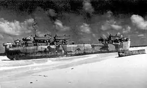
 LST-563 broached on Clipperton Island, 22 December 1944 | |
| History | |
|---|---|
| Name | USS LST-563 |
| Builder | Missouri Valley Bridge and Iron Company, Evansville, Indiana |
| Laid down | 4 March 1944 |
| Launched | 1 May 1944 |
| Sponsored by | Mrs. N. E. Senescall |
| Commissioned | 20 May 1944 |
| Stricken | 9 February 1945 |
| Fate | Wrecked 21 December 1944 |
| General characteristics | |
| Class and type | LST-542-class tank landing ship |
| Displacement |
|
| Length | 328 ft (100 m) |
| Beam | 50 ft (15 m) |
| Draft |
|
| Propulsion | 2 × General Motors 12-567 diesel engines, two shafts, twin rudders |
| Speed | 12 knots (22 km/h; 14 mph) |
| Boats & landing craft carried | 2 or 6 LCVPs |
| Troops | 14–16 officers, 131–147 enlisted men |
| Complement | 7–9 officers, 104–120 enlisted men |
| Armament |
|
USS LST-563 was an LST-542-class tank landing ship built for the United States Navy during World War II. She was in commission during 1944.
Construction and commissioning
LST-563 was laid down on 4 March 1944 at Evansville, Indiana, by the Missouri Valley Bridge and Iron Company. She was launched on 1 May 1944, sponsored by Mrs. N. E. Senescall, and commissioned on 20 May 1944.
Service history
During World War II, LST-563 was grounded on Clipperton Island in the eastern Pacific Ocean, 670 nautical miles (1,241 kilometers) southwest of Mexico, on 21 December 1944 and suffered extensive damage. After numerous unsuccessful attempts to free her, LST-563 was stripped and abandoned on 9 February 1945. She was struck from the Naval Vessel Register on 23 February 1945.
See also
References
- This article incorporates text from the public domain Dictionary of American Naval Fighting Ships. The entry can be found here.
- "LST-563". Dictionary of American Naval Fighting Ships. Retrieved 26 June 2007.
- "LST-563". Amphibious Photo Archive. Retrieved 26 June 2007.

10°18′26.69″N 109°14′5.66″W / 10.3074139°N 109.2349056°W