| Tuc del Caubo | |
|---|---|
 | |
| Highest point | |
| Elevation | 2,570 m (8,430 ft) |
| Prominence | 116 m (381 ft) |
| Isolation | 0.77 km (0.48 mi) |
| Coordinates | 42°40′25.27″N 1°15′49.06″E / 42.6736861°N 1.2636278°E |
| Geography | |
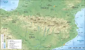 Tuc del Caubo Location in the Pyrenees | |
| Location | Pallars Sobirà, Catalonia, Spain |
| Parent range | Pyrenees |
| Climbing | |
| First ascent | Unknown |
| Easiest route | From Lladorre |
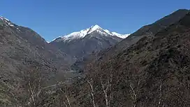
Tuc del Caubo is a mountain of Catalonia, Spain. Located in the Serra de Costuix, Pyrenees, it has an elevation of 2,570 metres above sea level.[1]
See also
References
- ↑ "Mapa Topogràfic de Catalunya". Institut Cartogràfic de Catalunya. Retrieved May 22, 2010..
This article is issued from Wikipedia. The text is licensed under Creative Commons - Attribution - Sharealike. Additional terms may apply for the media files.