| The Spit Sydney, New South Wales | |||||||||||||||
|---|---|---|---|---|---|---|---|---|---|---|---|---|---|---|---|
 Spit Bridge | |||||||||||||||
| Postcode(s) | 2088 | ||||||||||||||
| Location | 9 km (6 mi) north-east of Sydney CBD | ||||||||||||||
| LGA(s) | Municipality of Mosman | ||||||||||||||
| |||||||||||||||
.jpg.webp)
The Spit is an urban locality in the suburb of Mosman in Sydney, New South Wales, Australia. The Aboriginal word for The Spit is Burra Bra.[1] The Spit is located in the local government area of the Municipality of Mosman and is part of the Lower North Shore.
Landmarks
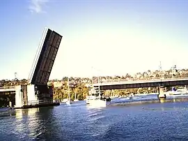
The Spit protrudes off Beauty Point and is home to the Spit Bridge, a bascule bridge opened in 1958 over Middle Harbour. The bridge opens at set times to allow yachts with high masts to pass. The Spit is the site of the Middle Harbour Yacht Club and a marina.
History
From as early as 1834, a ferry operated by Barney Kearns carried passengers across the waters of Middle Harbour. From the 1850s, a punt operated by Peter Ellery, carried passengers across for sixpence and horse-drawn vehicles were charged 1s 6d. If the horses swam across, there was a reduction of sixpence. In 1889, it was replaced by a government steam punt. A wooden bridge was opened in 1924 after the electric tram lines were extended to the Spit. This was replaced by the bascule bridge in 1958, which was needed to cope with heavy traffic from the Sydney CBD to the Northern Beaches. Chinamans Beach was named after the Chinese residents who had market gardens and salt pans there,[2] it is now a popular family beach.
Heritage listings
The Spit has a number of heritage-listed sites, including:
- Monash Crescent (East Side): Middle Harbour Syphon[3]
References
- ↑ "The Names of Sydney: Aboriginal".
- ↑ The Book of Sydney Suburbs, Compiled by Frances Pollen, Angus & Robertson Publishers, 1990, Published in Australia ISBN 0-207-14495-8, page 245
- ↑ "Middle Harbour Syphon NSOOS". New South Wales State Heritage Register. Department of Planning & Environment. H01628. Retrieved 18 May 2018.
 Text is licensed by State of New South Wales (Department of Planning and Environment) under CC-BY 4.0 licence.
33°48′50″S 151°14′35″E / 33.81394°S 151.24297°E