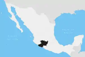
Tepalcatepec City | |
|---|---|
 Tepalcatepec City Location of Tepalcatepec in Mexico | |
| Coordinates: 19°11′N 102°51′W / 19.183°N 102.850°W | |
| Country | |
| State | Michoacán |
| Established | June 22, 1877 |
| Founded by | Alonso Avalos |
| Municipal seat | Tepalcatepec |
| Government | |
| • Municipal president | Felipe Martinez (PRI) |
| Area | |
| • Total | 780.22 km2 (301.24 sq mi) |
| Elevation | 370 m (1,210 ft) |
| Population (2010) | |
| • Total | 34,568[1] |
| Time zone | UTC-6 (CST) |
| • Summer (DST) | UTC-5 (CDT) |
Tepalcatepec is a city and municipality in the Mexican state of Michoacan. As of the 2010 census, it has a population of 34,678.
Geography
The municipality is located in the west of the state, 267 kilometres from the state capital of Morelia. It has an average altitude of 370 meters above sea level.
History
Before European settlement, the area was settled by the Chichimecas tribe.
On June 22, 1877, Tepalcatepec was established as a town.
A battle between the Jalisco New Generation Cartel and state defense forces in the town left 9 dead and 11 injured. Since 2020 the town has been on lockdown due to El Abuelos cartel turf war with El Menchos cartel.
References
- ↑ "Buenavista, Michoacán de Ocampo" (PDF). Informe Anual Sobre La Situación de Pobreza y Rezago Social. SEDESOL. Retrieved October 14, 2015.
This article is issued from Wikipedia. The text is licensed under Creative Commons - Attribution - Sharealike. Additional terms may apply for the media files.
