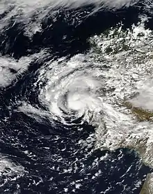
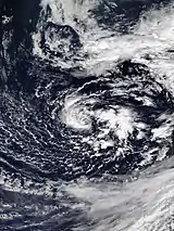
 Alpha shortly before landfall in Portugal on 18 September | |
| Meteorological history | |
|---|---|
| Formed | 17 September 2020 |
| Dissipated | 19 September 2020 |
| Subtropical storm | |
| 1-minute sustained (SSHWS/NWS) | |
| Highest winds | 50 mph (85 km/h) |
| Lowest pressure | 996 mbar (hPa); 29.41 inHg (992 mbar (29.29 inHg) while extratropical) |
| Overall effects | |
| Fatalities | 1 indirect |
| Damage | >$24.2 million (2020 USD) |
| Areas affected | Portugal, Spain |
| IBTrACS | |
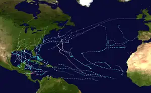
Part of the 2020 Atlantic hurricane season | |
Subtropical Storm Alpha was the first subtropical or tropical cyclone ever observed to make landfall in mainland Portugal. The twenty-second tropical or subtropical cyclone and twenty-first named storm of the extremely active and record-breaking 2020 Atlantic hurricane season, Alpha originated from a large non-tropical low that was first monitored by the National Hurricane Center on 15 September. Initially not anticipated to transition into a tropical cyclone, the low gradually tracked south-southeastward for several days with little development. By early on 17 September, the low had separated from its frontal features and exhibited sufficient organization to be classified as a subtropical cyclone, as it approached the Iberian Peninsula, becoming a subtropical storm around that time. Alpha then made landfall just south of Figueira da Foz, Portugal during the evening of 18 September, then rapidly weakened as it moved over the mountainous terrain of Northeastern Portugal. The system degenerated into a remnant low on 19 September, when it was last noted.
At least two EF1 tornadoes were confirmed in Portugal, and one person was killed due to strong winds in Spain. Impacts from Alpha were rather minor as a subtropical cyclone, although Alpha produced some significant rainfall and gusty winds in both Portugal and Spain as a remnant low.[1][2] Total damages from the storm were estimated to be greater than €20 million (US$24.2 million), with a majority of the damage occurring in Portugal.[3][4]
Meteorological history
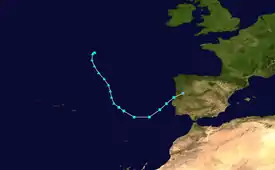
Tropical storm (39–73 mph, 63–118 km/h)
Category 1 (74–95 mph, 119–153 km/h)
Category 2 (96–110 mph, 154–177 km/h)
Category 3 (111–129 mph, 178–208 km/h)
Category 4 (130–156 mph, 209–251 km/h)
Category 5 (≥157 mph, ≥252 km/h)
Unknown
Alpha originated from a large, extratropical low-pressure area, which developed over the Northeastern Atlantic Ocean on 14 September.[1] As a strong upper-level trough dug southeastward and became a cut-off low about 500 nmi (580 mi; 930 km) north of the Azores, the interaction between the low and a surface front promoted the formation of a strong frontal low, which rapidly deepened and reached its extratropical peak that day, with maximum 1-minute sustained winds as high as 112 km/h (70 mph) and a minimum central atmospheric pressure of 992 mbar (29.3 inHg).[1] By this time, the extratropical cyclone had a very large radius of gale-force winds expanding over 500 km (270 nmi; 310 mi) from its center of circulation.[1] The low was initially very slow-moving, but began to dip southeastward and weaken by 15 September when the National Hurricane Center (NHC) first began to monitor the system for possible development into a tropical or subtropical cyclone.[1][5] This was because the system was expected to track close to a region of unusually-warm sea surface temperatures to the west of Portugal of around 22 °C (72 °F), though these temperatures would still typically be too cold to support tropical cyclogenesis.[1]
The size of the low's wind field continued gradually decreasing on 16 September, as some of its frontal features gradually became less defined, although the NHC only highlighted a low (20%) chance of development at this time, operationally.[1][6] Nonetheless, convection, or thunderstorm activity, became more concentrated and organized near the center of the low, and a newly formed central low soon became the dominant feature within the larger extratropical system.[7] In post-season analysis, the NHC estimated that Alpha had developed as a subtropical storm at 06:00 UTC on 17 September, as the thunderstorm activity associated with the smaller low feature became well-organized.[1] Alpha accelerated to the northeast, and a combination of radar imagery from Portugal, scatterometer passes, and satellite-derived wind data revealed Subtropical Storm Alpha had peaked around 00:00 UTC on 18 September, just about 417 km (225 nmi; 259 mi) off the coast of Portugal, while the storm was producing 1-minute sustained winds up to 80 km/h (50 mph).[1][8]
Alpha maintained its intensity up to its landfall about 17 km (11 mi) south of Figueira da Foz, Portugal, around 18:40 UTC that day.[1] The storm's final minimum central pressure estimate of 996 mbar (29.4 inHg) was based on a surface pressure of 999 mbar (29.5 inHg) being recorded in Monte Real, Portugal, well north of the cyclone's landfall point.[9] After landfall, the small low-level circulation associated with Alpha began to quickly decay, as the storm moved inland, and the cyclone weakened to a subtropical depression at 0:00 UTC on 19 September.[1] Alpha degenerated into a remnant low later that day, as it moved over the mountainous terrain of Northeastern Portugal.[1]
Preparations and impact
In preparation for Alpha in Portugal on 18 September, orange warnings were raised by the Portuguese Institute of the Sea and Atmosphere (IPMA), due to the threat of high wind and heavy rain in the Coimbra and Leiria districts of Portugal.[10] Winds due to Alpha caused widespread power outages, uprooted trees, and damaged dozens of vehicles.[11] A squall line producing gusts as high as 80 km/h (50 mph) associated with the system spawned at least two confirmed tornadoes of EF1 intensity; one near the town of Palmela, which caused no reported damage, and one in Beja, which uprooted around 100 trees and damaged 30–40 vehicles.[1][11][12] There were some reports of minor roof damage to some structures as well, deemed to be related to the Beja tornado.[1] Street flash flooding, as a result of heavy rainfall became prominent in some cities in western Portugal; the flooding was most severe in Setúbal.[11] 68.2 mm (2.69 in) of rain fell in Porto, while wind gusts reached as high as 90 km/h (56 mph) in Monte Real.[13] High surf caused by Alpha in Carcavelos Beach (Portuguese: Praia de Carcavelos) caused minor coastal erosion.[14] Winds brought down a radio tower in Leiria, where it was reported to have been damaged beyond repair.[15] Throughout the country, there were 203 reports of trees uprooted, 174 reports of minor flooding, 88 structures damaged and 82 roads blocked by debris. Of these reports, 143 were in Leiria District and 135 were in Lisbon District.[16] Alpha caused an estimated €20 million (US$24.2 million) in damage in Portugal before the region would later be hit by another significant storm, Windstorm Barbara, in late October.[3]
In Spain, orange warnings were also raised by the State Meteorological Agency (AEMET) for the Spanish autonomous communities of Madrid, Extremadura, Aragon, and Catalonia as Alpha moved into Portugal late on 18 September, citing a risk of heavy rain, hail, and strong wind gusts.[17] Yellow alerts were also issued in Castile and León and Castilla–La Mancha.[17] Rain and windy conditions spread further inland into Spain, while the remnants moved eastward.[2] Castilla–La Mancha's news agency reported that uprooted trees and minor floods had occurred in the community during Alpha, while several water rescues were carried out around midday of 19 September.[18] The fast-moving cluster of thunderstorms associated with the remnants of Alpha produced 38 mm (1.5 in) of rain in half an hour in Valencia before the remnants exited into the Mediterranean Sea.[19] Wind gusts of up to 94 km/h (58 mph) were reported in the town of Coria, Cáceres.[13] The remnants of Alpha caused a train with 25 passengers to derail in Madrid, although no one was seriously injured. A woman died in Calzadilla after the roof of a cattle shed collapsed on top of her.[20][1] Alpha also caused lightning on Ons Island, which led to an isolated forest fire.[20]
Distinctions and naming
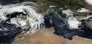
Alpha was the earliest 22nd Atlantic tropical or subtropical storm on record, surpassing the old mark of October 17, set by Hurricane Wilma in 2005.[21] It developed at an unusually eastern longitude – 18.0°W; only Tropical Storm Christine in 1973 developed farther to the east, at 14.0°W.[1] Upon landfall, Alpha became the first recorded tropical or subtropical cyclone known to have made landfall in Portugal.[22] Additionally, Cyclone Ianos was approaching its first landfall in Greece at the time; this marked the first time in recorded history that two storms of subtropical or tropical nature impacted continental Europe simultaneously.[23]
The 2020 season was the second (along with 2005) in which an alphabetic list of 21 storm names had been exhausted, necessitating use of the Greek alphabet auxiliary list.[24] In March 2021, the World Meteorological Organization replaced that auxiliary list with a new 21-name supplemental list. As a result, the name Alpha will not be used to name another Atlantic hurricane.[25]
See also
- Tropical cyclones in 2020
- Timeline of the 2020 Atlantic hurricane season
- Other storms of the same name
- 1842 Spain hurricane – only storm known to have made landfall in the Iberian Peninsula at hurricane strength
- Hurricane Leslie (2018) – long-lived Atlantic hurricane whose extratropical remnant made landfall in Portugal
- Hurricane Vince – made landfall in Spain as a tropical depression
- Hurricane Pablo – similar track and location
References
- 1 2 3 4 5 6 7 8 9 10 11 12 13 14 15 16 Brown, Daniel (28 January 2021). "Subtropical Storm Alpha" (PDF). Tropical Cyclone Report. Miami, Florida: National Hurricane Center. Retrieved 14 May 2021.
- 1 2 ""Unique" Iberian subtropical storm recorded". www.theportugalnews.com. The Portugal News. 25 September 2020. Retrieved 14 May 2021.
- 1 2 "Catástrofes naturais custaram a Portugal mais de 50 milhões de euros em 2020". www.tsf.pt (in Portuguese). TSF. 11 February 2021. Retrieved 14 May 2021.
- ↑ "Global Catastrophe Recap September 2020" (PDF). Aon. 8 October 2020. Archived (PDF) from the original on 8 October 2020. Retrieved 8 October 2020.
- ↑ Blake, Eric (15 September 2020). "Two-Day Graphical Tropical Weather Outlook". nhc.noaa.gov. Miami, Florida: National Hurricane Center. Retrieved 18 September 2020.
- ↑ Berg, Robbie (15 September 2020). "Two-Day Graphical Tropical Weather Outlook". nhc.noaa.gov. Miami, Florida: National Hurricane Center. Retrieved 18 September 2020.
- ↑ Andrew Latto (17 September 2020). "Two-Day Graphical Tropical Weather Outlook". nhc.noaa.gov. Miami, Florida: National Hurricane Center. Retrieved 18 September 2020.
- ↑ Blake, Eric (18 September 2020). "Subtropical Storm Alpha Special Discussion Number 1". nhc.noaa.gov. Miami, Florida: National Hurricane Center. Retrieved 18 September 2020.
- ↑ Blake, Eric (18 September 2020). "Subtropical Storm Alpha Discussion Number 2". nhc.noaa.gov. Miami, Florida: National Hurricane Center. Retrieved 18 September 2020.
- ↑ "Ciclone Alpha: Aviso laranja por agravamento de mau tempo hoje no distrito de Coimbra | Notícias de Coimbra". www.noticiasdecoimbra.pt (in Portuguese). Notícias de Coimbra. 18 September 2020. Retrieved 18 September 2020.
- 1 2 3 "Tornados em Beja e Palmela ocorreram devido a supercélulas. Fim de semana chega com a tempestade subtropical Alpha" (in Portuguese). Observador. 18 September 2020. Retrieved 14 May 2021.
- ↑ Meteo Trás-os-Montes - Portugal [@MateoTrasMontPT] (18 September 2020). "TornadoCloud with tornado em é Lagameças, perto de #Setubal. Impressionante! Credit: Café Esperança #Invest99L" (Tweet) (in Portuguese). Retrieved 7 February 2021 – via Twitter.
- 1 2 marekkucera (20 September 2020). "Tropical storm Alpha in Europe: Floods in Spain, Portugal and France, Easternmost-forming tropical storm ever". mkweather. Retrieved 14 May 2021.
- ↑ "Visão | Areal da Praia de Carcavelos engolido pela água durante o ciclone Alpha. Veja as fotos". Visão (in European Portuguese). 18 September 2020. Retrieved 14 May 2021.
- ↑ Rainho, Martine (19 September 2020). "Leiria: Ciclone Alpha derruba torre da Rádio 94FM". Região de Leiria (in European Portuguese). Retrieved 19 September 2020.
- ↑ "Quedas de árvores, inundações e estruturas que caíram. Foram registadas 555 ocorrências devido ao mau tempo e mantém-se aviso amarelo" (in Portuguese). SAPO. 19 September 2020. Retrieved 19 September 2020.
- 1 2 "Una borrasca con tintes de ciclón azota España: sigue en tiempo real su evolución". www.elconfidencial.com (in Spanish). 18 September 2020. Retrieved 13 May 2021.
- ↑ "Las tormentas dejan calles inundadas y árboles caídos en Toledo y Cuenca". Encastillalamancha (in Spanish). 19 September 2020. Retrieved 13 May 2021.
- ↑ "Las fuertes lluvias en la provincia de Valencia dejan casi 40 litros en menos de una hora en algunos puntos". Cadena SER (in Spanish). 19 September 2020. Retrieved 13 May 2021.
- 1 2 "Los estragos del temporal: Una mujer muere en Cáceres al caer un tejado y un tren descarrila en Madrid". telecinco (in European Spanish). 18 September 2020. Retrieved 18 September 2020.
- ↑ Sosnowski, Alex (17 September 2020) [Updated 20 September 2020]. "Tropical Storm Beta to spend days pounding Gulf Coast". newscentermaine.com. Portland, Maine: WCSH. Retrieved 6 November 2020.
- ↑ Masters, Jeff; Henson, Bob (18 September 2020). "A slew of weather events – including two named storms troubling Europe – pose challenges far and wide". Yale Climate Connections. New Haven, Connecticut: Yale Center for Environmental Communication, Yale School of the Environment. Retrieved 6 November 2020.
- ↑ Blašković, Teo (21 September 2021). "Mainland Portugal hit by its first (sub)tropical cyclone on record". The Watchers - Daily news service | Watchers.NEWS. Retrieved 14 May 2021.
- ↑ Machemer, Theresa (24 September 2020). "Out of Names, National Hurricane Center Calls New Storms by Greek Letters". Smithsonian. Retrieved 5 November 2020.
- ↑ "WMO Hurricane Committee retires tropical cyclone names and ends the use of Greek alphabet". Geneva, Switzerland: World Meteorological Organization. 17 March 2021. Archived from the original on 18 December 2023. Retrieved 17 March 2021.
External links
- The National Hurricane Center's Advisory Archive on Subtropical Storm Alpha
- National Hurricane Center (NHC)
