| Stinking River Tributary to Banister River | |
|---|---|
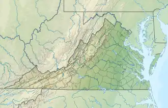 Location of Stinking River mouth  Stinking River (the United States) | |
| Location | |
| Country | United States |
| State | Virginia |
| County | Pittsylvania |
| Physical characteristics | |
| Source | Little Sycamore Creek divide |
| • location | about 3 miles southeast of Sycamore, Virginia |
| • coordinates | 36°59′59″N 079°19′21″W / 36.99972°N 79.32250°W[1] |
| • elevation | 980 ft (300 m)[2] |
| Mouth | |
• location | about 2.5 miles south of Mt. Airy, Virginia |
• coordinates | 36°54′26″N 079°11′35″W / 36.90722°N 79.19306°W[1] |
• elevation | 441 ft (134 m)[3] |
| Length | 14.18 mi (22.82 km)[4] |
| Basin size | 34.25 square miles (88.7 km2)[5] |
| Discharge | |
| • location | Banister River |
| • average | 41.70 cu ft/s (1.181 m3/s) at mouth with Banister River[5] |
| Basin features | |
| Progression | Banister River → Dan River → Roanoke River → Albemarle Sound → Pamlico Sound → Atlantic Ocean |
| River system | Roanoke River |
| Tributaries | |
| • left | North Fork Stinking River Maggotty Creek Dry Branch Flyblow Creek |
| • right | West Fork Stinking River |
| Bridges | Deer View Road, Tucker Road, Midway Road, Tucker Road, Telegraph Road, Tates Mill Road, VA 40, Hickeys Road, Johnson Mill Road |
The Stinking River is a short tributary of the Banister River in southern Virginia in the United States. Via the Banister and Dan Rivers, it is part of the watershed of the Roanoke River, which flows to the Atlantic Ocean. The Stinking River flows for its entire length in Pittsylvania County.
Course
Stinking River rises about 3 miles southeast of Sycamore, Virginia and then flows southeast to join the Banister River about 2.5 miles south of Mt. Airy.[3]
Watershed
Stinking River drains 34.25 square miles (88.7 km2) of area, receives about 45.4 in/year of precipitation, has a wetness index of 422.79, and is about 53% forested.[5]
See also
References
- 1 2 "GNIS Detail - Stinking River". geonames.usgs.gov. US Geological Survey. Retrieved 6 August 2021.
- ↑ "Get Maps". USGS Topoview. US Geological Survey. Retrieved 6 August 2021.
- 1 2 "Get Maps". USGS Topoview. US Geological Survey. Retrieved 6 August 2021.
- ↑ "ArcGIS Web Application". epa.maps.arcgis.com. US EPA. Retrieved 6 August 2021.
- 1 2 3 "Stinking River Watershed Report". US EPA Geoviewer. US EPA. Retrieved 6 August 2021.
- DeLorme (2005). Virginia Atlas & Gazetteer. Yarmouth, Maine: DeLorme. ISBN 0-89933-326-5.
- U.S. Geological Survey Geographic Names Information System: Stinking River
This article is issued from Wikipedia. The text is licensed under Creative Commons - Attribution - Sharealike. Additional terms may apply for the media files.