Stan Shuatuk, Arizona | |
|---|---|
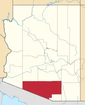
 Stan Shuatuk Location within the state of Arizona  Stan Shuatuk Stan Shuatuk (the United States) | |
| Coordinates: 31°47′56″N 112°18′01″W / 31.79889°N 112.30028°W | |
| Country | United States |
| State | Arizona |
| County | Pima |
| Elevation | 1,722 ft (540 m) |
| Time zone | UTC-7 (Mountain (MST)) |
| • Summer (DST) | UTC-7 (MST) |
| Area code | 520 |
| FIPS code | 04-69200 |
| GNIS feature ID | 24625 |
Stan Shuatuk is a populated place situated in Pima County, Arizona, United States, just north of the international border with Mexico.[2] Historically, it has also been known as Cervantis Well, La Moralita, Molinitos, Molinton, Molonitos, and Serventi Well. In 1941, the name officially became Stan Shuatuk through a decision by the Board on Geographic Names. The name request came through a request by the Bureau of Indian Affairs, who stated that Stan Shuatuk was "used and understood by the residents and Papagos (Tohono O'odham) in general."[note 1] In O'odham, stan shuatuk means "hot water". It has an estimated elevation of 1,772 feet (540 m) above sea level.[1]
Notes
- ↑ For the information on the name request, please see the "decision card", the link of which can be found on the GNIS webpage.
References
- 1 2 "Feature Detail Report for: Stan Shuatuk". Geographic Names Information System. United States Geological Survey, United States Department of the Interior.
- ↑ "Stan Shuatuk (in Pima County, AZ) Populated Place Profile". AZ Hometown Locator. Retrieved April 5, 2017.
This article is issued from Wikipedia. The text is licensed under Creative Commons - Attribution - Sharealike. Additional terms may apply for the media files.
