Springdale Township, Cedar County | |
|---|---|
 | |
| Coordinates: 41°38′30″N 091°18′29″W / 41.64167°N 91.30806°W | |
| Country | |
| State | |
| County | Cedar |
| Area | |
| • Total | 36.37 sq mi (94.21 km2) |
| • Land | 36.37 sq mi (94.21 km2) |
| • Water | 0 sq mi (0 km2) |
| Elevation | 719 ft (219 m) |
| Population (2000) | |
| • Total | 2,857 |
| • Density | 78.6/sq mi (30.3/km2) |
| FIPS code | 19-93975[2] |
| GNIS feature ID | 0468739 |
Springdale Township is one of seventeen townships in Cedar County, Iowa, USA. As of the 2000 census, its population was 2,857.
History
Springdale Township was established in 1853.[3] Springdale Township was an important point on the Underground Railroad.[4]
Geography
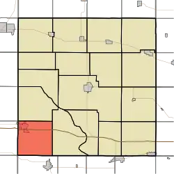
Springdale Township covers an area of 36.37 square miles (94.2 km2) and contains one incorporated settlement, West Branch. According to the USGS, it contains six cemeteries: Chamness, Downey, Hickory Grove, Old Friends, Springdale and West Branch. The unincorporated community of Springdale was historically important in the anti-slavery movement.
References
- ↑ "US Board on Geographic Names". United States Geological Survey. October 25, 2007. Retrieved January 31, 2008.
- ↑ "U.S. Census website". United States Census Bureau. Retrieved January 31, 2008.
- ↑ Aurner, Clarence Ray (1910). A Topical History of Cedar County, Iowa, Volume 1. S. J. Clarke. pp. 127.
- ↑ The History of Cedar County, Iowa: Containing a History of the County, Its Cities, Towns, etc. Western Historical Company. 1878. p. 518.
External links
Wikimedia Commons has media related to Springdale Township, Cedar County, Iowa.
Municipalities and communities of Cedar County, Iowa, United States | ||
|---|---|---|
| Cities | Map of Iowa highlighting Cedar County | |
| Townships | ||
| CDPs | ||
| Other communities | ||
| Footnotes | ‡This populated place also has portions in an adjacent county or counties | |
This article is issued from Wikipedia. The text is licensed under Creative Commons - Attribution - Sharealike. Additional terms may apply for the media files.