Seydikemer | |
|---|---|
District and municipality | |
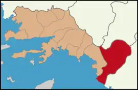
 Map showing Seydikemer District in Muğla Province | |
 Seydikemer Location in Turkey  Seydikemer Seydikemer (Turkey Aegean) | |
| Coordinates: 36°38′53″N 29°21′42″E / 36.64806°N 29.36167°E | |
| Country | Turkey |
| Province | Muğla |
| Area | 2,208 km2 (853 sq mi) |
| Population (2022)[1] | 62,622 |
| • Density | 28/km2 (73/sq mi) |
| Time zone | TRT (UTC+3) |
| Area code | 0252 |
| Website | www |
Seydikemer is a municipality and district of Muğla Province, Turkey.[2] Its area is 2,208 km2,[3] and its population is 62,622 (2022).[1]
The district and municipality Seydikemer was created at the 2013 Turkish local government reorganisation from part of the district of Fethiye, including the former municipality Kemer.[4][5] The name refers to Kemer and the adjacent village Seydiler.
Located some 30 kilometres (19 mi) inland from Fethiye, this remains very much a traditional Turkish town. There are nevertheless a few expats living here.
Composition
There are 65 neighbourhoods in Seydikemer District:[6]
- Alaçat
- Arifler
- Arsaköy
- Atlıdere
- Bağlıağaç
- Bayırköy
- Bekçiler
- Belen
- Boğalar
- Boğaziçi
- Çaltılar
- Çaltıözü
- Çamurköy
- Çatak
- Çayan
- Çaykenarı
- Ceylan
- Çobanisa
- Çobanlar
- Çökek
- Çukurincir
- Cumhuriyet
- Demirler
- Dereköy
- Dodurga
- Doğanlar
- Dont
- Düğer
- Eşen
- Gerişburnu
- Girmeler
- Gölbent
- Güneşli
- Hacıosmanlar
- İzzetinköy
- Kabaağaç
- Kadıköy
- Karadere
- Karaköy
- Kayabaşı
- Kayacık
- Kayadibi
- Kıncılar
- Kınık
- Korubükü
- Kumluova
- Menekşe
- Minare
- Ören
- Ortaköy
- Paşalı
- Sahil Ceylan
- Sarıyer
- Seki
- Seydiler
- Söğütlüdere
- Temel
- Uğurlu
- Yakabağ
- Yakaköy
- Yayla Eldirek
- Yayla Gökben
- Yayla Karaçulha
- Yaylapatlangıç
- Zorlar
Attractions
Popular places are Saklıkent National Park, Tlos, Letoon, Pinara, Sidyma, Erendag and Oenoanda.
References
- 1 2 "Address-based population registration system (ADNKS) results dated 31 December 2022, Favorite Reports" (XLS). TÜİK. Retrieved 19 September 2023.
- ↑ Büyükşehir İlçe Belediyesi, Turkey Civil Administration Departments Inventory. Retrieved 19 September 2023.
- ↑ "İl ve İlçe Yüz ölçümleri". General Directorate of Mapping. Retrieved 19 September 2023.
- ↑ "İl İdaresi ve Mülki Bölümler Şube Müdürlüğü İstatistikleri - İl ve İlçe Kuruluş Tarihleri" (PDF) (in Turkish). p. 64. Retrieved 27 September 2023.
- ↑ "Law No. 6360". Official Gazette (in Turkish). 6 December 2012.
- ↑ Mahalle, Turkey Civil Administration Departments Inventory. Retrieved 19 September 2023.
This article is issued from Wikipedia. The text is licensed under Creative Commons - Attribution - Sharealike. Additional terms may apply for the media files.
