Searingtown, New York | |
|---|---|
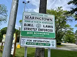
 A welcome sign to Searingtown at the intersection of Herricks, Shelter Rock, and Searingtown Roads. | |
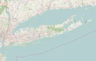
 Location in Nassau County and the state of New York. | |
 Searingtown, New York Location on Long Island  Searingtown, New York Location within the state of New York | |
| Coordinates: 40°46′21″N 73°39′30″W / 40.77250°N 73.65833°W | |
| Country | |
| State | |
| County | Nassau |
| Town | North Hempstead |
| Named for | The Searing family |
| Area | |
| • Total | 0.93 sq mi (2.41 km2) |
| • Land | 0.93 sq mi (2.41 km2) |
| • Water | 0.00 sq mi (0.00 km2) |
| Elevation | 128 ft (39 m) |
| Population (2020) | |
| • Total | 5,044 |
| • Density | 5,412.02/sq mi (2,090.15/km2) |
| Time zone | UTC-5 (Eastern (EST)) |
| • Summer (DST) | UTC-4 (EDT) |
| Area codes | 516, 363 |
| FIPS code | 36-66102 |
| GNIS feature ID | 0964742 |
Searingtown is a hamlet and census-designated place (CDP) in the Town of North Hempstead in Nassau County, on Long Island, in New York, United States. It is considered part of the Greater Roslyn area, which is anchored by the Village of Roslyn. The population was 4,915 at the 2010 census.
Searingtown has two zip codes, corresponding to both Roslyn and Albertson respectively.
History
One of the earliest settlers in the area was named John Searing. The name of the hamlet became Searingtown in the mid-18th Century; the Searing family was the area's principal owner of land at the time.[2] The Searingtown Methodist Church first opened on I.U. Willets Road (formerly Westbury Road) in 1788.[2][3] Parts of the original structure are still part of the church. The building still stands in the same place but it is technically now in Albertson.[4]
Geography

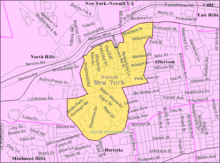
According to the United States Census Bureau, the CDP has a total area of 0.9 square miles (2.3 km2), all land.[5]
Demographics
| Census | Pop. | Note | %± |
|---|---|---|---|
| 2020 | 5,044 | — | |
| U.S. Decennial Census[6] | |||
As of the census[7] of 2000, there were 5,034 people, 1,582 households, and 1,430 families residing in the CDP. The population density was 5,473.4 inhabitants per square mile (2,113.3/km2). There were 1,606 housing units at an average density of 1,746.2 per square mile (674.2/km2). The racial makeup of the CDP was 69.77% White, 0.99% African American, 0.10% Native American, 25.86% Asian, 0.70% from other races, and 2.58% from two or more races. Hispanic or Latino of any race were 2.86% of the population.
There were 1,582 households, out of which 41.9% had children under the age of 18 living with them, 83.1% were married couples living together, 5.3% had a female householder with no husband present, and 9.6% were non-families. 8.7% of all households were made up of individuals, and 6.0% had someone living alone who was 65 years of age or older. The average household size was 3.18 and the average family size was 3.37.
In the CDP, the population was spread out, with 26.8% under the age of 18, 6.2% from 18 to 24, 21.8% from 25 to 44, 29.0% from 45 to 64, and 16.2% who were 65 years of age or older. The median age was 42 years. For every 100 females, there were 94.6 males. For every 100 females age 18 and over, there were 90.2 males.
The median income for a household in the CDP was $120,546, and the median income for a family was $126,182. Males had a median income of $92,834 versus $51,995 for females. The per capita income for the CDP was $49,113. About 1.1% of families and 1.1% of the population were below the poverty line, including 1.0% of those under age 18 and 2.1% of those age 65 or over.
Government
Town representation
As Searingtown is an unincorporated part of the Town of North Hempstead, it is directly governed by the town's government in Manhasset.[8][9]
As of September 2021, Searingtown is represented on the Town Board by Peter J. Zuckerman (D–East Hills), and is located in its 2nd Council District.[9]
Representation in higher government
Nassau County representation
Searingtown is primarily located in Nassau County's 10th Legislative district, which as of January 2023 is represented in the Nassau County Legislature by Mazi Melesa Pilip (R–Great Neck).[8][10] However a small portion of the hamlet is within Nassau County's 9th Legislative District, which as of September 2021 was represented in the Nassau County Legislature by Richard Nicoello (R–New Hyde Park).[8][11]
New York State representation
New York State Assembly
Searingtown is located in the New York State Assembly's 16th Assembly district, which as of September 2021 is represented by Gina Sillitti (D–Manorhaven).[8][12]
New York State Senate
Searingtown is located in the New York State Senate's 7th State Senate district, which as of September 2021 is represented in the New York State Senate by Anna Kaplan (D–North Hills).[8][13]
Federal representation
United States Congress
Searingtown is located in New York's 3rd congressional district, which as of 2023 is represented in the United States Congress by indicted fraudster George Santos, GOP.
United States Senate
Like the rest of New York, Searingtown is represented in the United States Senate by Charles Schumer (D) and Kirsten Gillibrand (D).[14]
Politics
In the 2016 U.S. presidential election, the majority of Searingtown voters voted for Hillary Clinton (D).[15]
Education
Searingtown is served by the Herricks Union Free School District.[16] As such, all children who reside within the hamlet and attend public schools go to that district's schools.[16]
Furthermore, the following schools, which are operated by the aforementioned district, are located within the hamlet:[16]
- Searingtown Elementary School
- Herricks Middle School
- Herricks High School
Infrastructure
Transportation
Road
A small portion of the Northern State Parkway forms much of the northern border of Searingtown; the historic Long Island Motor Parkway used to pass through the hamlet, as well.[16][17][18][19][20]
Other major roads which travel through Searingtown include I.U. Willets Road, Searingtown Road, Shelter Rock Road, and Willis Avenue.[16]
Rail
No rail lines pass through Searingtown.[16] The nearest Long Island Rail Road stations to the hamlet are Manhasset on the Port Washington Branch, New Hyde Park on the Main Line and Albertson on the Oyster Bay Branch.[16]
Bus
The n23 bus route runs along Willis Avenue at the eastern edge of Searingtown.[21] This bus line is operated by Nassau Inter-County Express (NICE).[21]
Utilities
Natural gas
National Grid USA provides natural gas to homes and businesses that are hooked up to natural gas lines in Searingtown.[22]
Power
PSEG Long Island provides power to all homes and businesses within Searingtown.[22]
The former Motor Parkway's right-of-way now serves as the route of a power line through the area.[19][23]
Sewage
All of Searingtown is connected to sanitary sewers, which are part of the Nassau County Sewage District, which handles and treats the hamlet's sanitary waste.[16][24]
Water
Searingtown is primarily located within the boundaries of (and is thus served by) the Albertson Water District.[16] However, much of the southern part of the hamlet is located within the boundaries of (and is thus served by) the Garden City Park Water District.[16]
References
- ↑ "ArcGIS REST Services Directory". United States Census Bureau. Retrieved September 20, 2022.
- 1 2 Winsche, Richard (October 1, 1999). The History of Nassau County Community Place-Names. Interlaken, New York: Empire State Books. ISBN 978-1557871541.
- ↑ "[Property maps of North Hempstead and Oyster Bay Townships, Nassau County, N.Y.] - Map Collections". Map Collections – Brooklyn Public Library. Retrieved April 1, 2023.
- ↑ Rather, John. Classic Suburb Keeps Its Appeal in the 90's. The New York Times, July 20, 1997. Retrieved June 8th, 2010.
- ↑ "US Gazetteer files: 2010, 2000, and 1990". United States Census Bureau. February 12, 2011. Retrieved April 23, 2011.
- ↑ "Census of Population and Housing". Census.gov. Retrieved June 4, 2016.
- ↑ "U.S. Census website". United States Census Bureau. Retrieved January 31, 2008.
- 1 2 3 4 5 "Long Island Index: Interactive Map". www.longislandindexmaps.org. Retrieved June 28, 2021.
- 1 2 "Town of North Hempstead - Councilman Peter J. Zuckerman (2nd District)". www.northhempsteadny.gov. Retrieved June 29, 2021.
- ↑ "District 10 - Ellen W. Birnbaum | Nassau County, NY - Official Website". www.nassaucountyny.gov. Retrieved September 12, 2021.
- ↑ "District 9 - Richard J. Nicolello | Nassau County, NY - Official Website". www.nassaucountyny.gov. Retrieved July 22, 2021.
- ↑ "Gina L. Sillitti - Assembly District 16 |Assembly Member Directory | New York State Assembly". nyassembly.gov. Retrieved July 22, 2021.
- ↑ "NY Senate District 7". NY State Senate. Retrieved July 22, 2021.
- ↑ "U.S. Senate: Contacting U.S. Senators". www.senate.gov. Retrieved July 22, 2021.
- ↑ Welch, Will (November 8, 2017). "How Long Island Voted". Newsday. Retrieved June 23, 2021.
- 1 2 3 4 5 6 7 8 9 10 "Long Island Index: Interactive Map". www.longislandindexmaps.org. Retrieved June 29, 2021.
- ↑ "LIers want to preserve 106-year-old bridge". Newsday. Retrieved August 30, 2021.
- ↑ "Long Island Motor Parkway". www.nycroads.com. Retrieved August 30, 2021.
- 1 2 Kroplick, Howard; Velocci, Al (2008). Long Island Motor Parkway. Arcadia Publishing. ISBN 9780738557939.
- ↑ "Vanderbilt Cup Races - Blog - A Map of the Long Island Motor Parkway & Queens Historical Sites". www.vanderbiltcupraces.com. Retrieved August 19, 2021.
- 1 2 "Nassau Inter-County Express - Maps and Schedules". www.nicebus.com. Retrieved August 19, 2021.
- 1 2 "Long Island Utility Information - LIPA, Nat Grid, & Local Water Authorities". LongIsland.com. Retrieved October 24, 2020.
- ↑ Patton, Phil (October 9, 2008). "A 100-Year-Old Dream: A Road Just for Cars". The New York Times. ISSN 0362-4331. Retrieved August 30, 2021.
- ↑ "Sewerage Map – Nassau County". County of Nassau, New York. Retrieved August 5, 2021.