| Schweinskopf | |
|---|---|
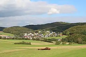 The Schweinsberg from the southwest. In the foreground is the village of Herzhausen
_-_Aussicht_vom_Wurstberg_(006).JPG.webp) Summits on the horizon: to the left is the centre of the Hornberg and, to its right are the Eichelhardt and the Schweinskopf. | |
| Highest point | |
| Elevation | 473 m (1,552 ft) |
| Prominence | 58 m ↓ Kreisstraße Friedensdorf–Weitershausen |
| Isolation | 2.4 km → Kappe[lower-alpha 1] |
| Coordinates | 50°49′54″N 8°34′14″E / 50.831663°N 8.570671°E |
| Geography | |
 Schweinskopf | |
| Parent range | Damshäuser Kuppen, Gladenbach Uplands |
The Schweinskopf is a hill, 473 metres high,[lower-alpha 2] in the German state of Hesse. The hill is part of the Damshausen Heights (Damshäuser Kuppen). Situated on the edge of the village of Friedensdorf, it is the highest elevation in the parish.
After the Rimberg (497.1 m) and the Kappe (493.5 m), it is the third highest summit in the Damshausen Heights and highest point of the western part of the range.
Location
The hill summit is about 800 metres east of Herzhausen and 800 metres south of the Eichelhardt (465 m). It is about 1.7 kilometres from Friedensdorf.[1]
Footnotes
References
- ↑ map and aerial photo of the Damshausen Heights with all hills and rivers / Placemarks (Google Earth required)
This article is issued from Wikipedia. The text is licensed under Creative Commons - Attribution - Sharealike. Additional terms may apply for the media files.