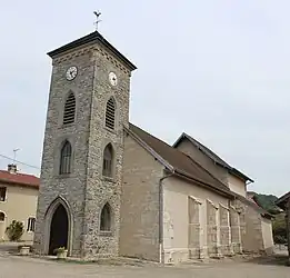
Samognat | |
|---|---|
Commune | |
 | |
Location of Samognat | |
 Samognat 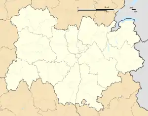 Samognat | |
| Coordinates: 46°15′31″N 5°34′37″E / 46.2586°N 5.5769°E | |
| Country | France |
| Region | Auvergne-Rhône-Alpes |
| Department | Ain |
| Arrondissement | Nantua |
| Canton | Pont-d'Ain |
| Intercommunality | Haut-Bugey Agglomération |
| Government | |
| • Mayor (2020–2026) | Annie Escoda[1] |
| Area 1 | 14.01 km2 (5.41 sq mi) |
| Population | 660 |
| • Density | 47/km2 (120/sq mi) |
| Time zone | UTC+01:00 (CET) |
| • Summer (DST) | UTC+02:00 (CEST) |
| INSEE/Postal code | 01392 /01580 |
| Elevation | 288–731 m (945–2,398 ft) (avg. 437 m or 1,434 ft) |
| 1 French Land Register data, which excludes lakes, ponds, glaciers > 1 km2 (0.386 sq mi or 247 acres) and river estuaries. | |
Samognat (French pronunciation: [samɔɲa]) is a commune in the Ain department in eastern France.
Population
| Year | Pop. | ±% p.a. |
|---|---|---|
| 1968 | 119 | — |
| 1975 | 156 | +3.94% |
| 1982 | 238 | +6.22% |
| 1990 | 285 | +2.28% |
| 1999 | 422 | +4.46% |
| 2009 | 712 | +5.37% |
| 2014 | 668 | −1.27% |
| 2020 | 654 | −0.35% |
| Source: INSEE[3] | ||
See also
References
- ↑ "Répertoire national des élus: les maires" (in French). data.gouv.fr, Plateforme ouverte des données publiques françaises. 13 September 2022.
- ↑ "Populations légales 2021". The National Institute of Statistics and Economic Studies. 28 December 2023.
- ↑ Population en historique depuis 1968, INSEE
Wikimedia Commons has media related to Samognat.
This article is issued from Wikipedia. The text is licensed under Creative Commons - Attribution - Sharealike. Additional terms may apply for the media files.