Sainte-Pience | |
|---|---|
Part of Le Parc | |
 The church of Sainte-Pience | |
Location of Sainte-Pience | |
 Sainte-Pience 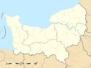 Sainte-Pience | |
| Coordinates: 48°45′52″N 1°18′05″W / 48.7644°N 1.3014°W | |
| Country | France |
| Region | Normandy |
| Department | Manche |
| Arrondissement | Avranches |
| Canton | Bréhal |
| Commune | Le Parc |
| Area 1 | 8.68 km2 (3.35 sq mi) |
| Population (2013)[1] | 318 |
| • Density | 37/km2 (95/sq mi) |
| Time zone | UTC+01:00 (CET) |
| • Summer (DST) | UTC+02:00 (CEST) |
| Postal code | 50870 |
| Elevation | 105–201 m (344–659 ft) (avg. 203 m or 666 ft) |
| 1 French Land Register data, which excludes lakes, ponds, glaciers > 1 km2 (0.386 sq mi or 247 acres) and river estuaries. | |
Sainte-Pience (French pronunciation: [sɛ̃t pjɑ̃s]) is a former commune in the Manche department in Normandy in north-western France.[2] On 1 January 2016, it was merged into the new commune of Le Parc.[3]
See also
References
- ↑ Populations légales 2013: Téléchargement du fichier d'ensemble, INSEE
- ↑ Des villages de Cassini aux communes d'aujourd'hui: Commune data sheet Sainte-Pience, EHESS (in French).
- ↑ Arrêté préfectoral 4 November 2015 (in French)
Wikimedia Commons has media related to Sainte-Pience.
This article is issued from Wikipedia. The text is licensed under Creative Commons - Attribution - Sharealike. Additional terms may apply for the media files.