| Route nationale 10 | |
|---|---|
| Route information | |
| Length | 512 km (318 mi) |
| Major junctions | |
| to end | RN 13 (Ambovombe) |
| from RN 7
| |
| Location | |
| Country | Madagascar |
| Highway system | |

another unpaved Route nationale in Madagascar
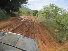
Route nationale 10 (RN 10) is an unpaved, secondary highway in Madagascar of 512 km, running from Andranovory to Ambovombe. It crosses the regions of Atsimo-Andrefana and Androy.
Selected locations on route
West to East:
- Andranovory - intersection with RN 7 (Tulear - Fianarantsoa - Antananarivo)
- Tameantsoa - Onilahy River crossing
- Betioky - Beza Mahafaly Reserve at 35 km north-east
- Ambatry
- Mahazoarivo - intersection secondary road to Vohitsara and Akazomateila (Mahafaly graves) & Tsimanampetsotse National Park
- Ejeda - dirt road to the coast to Itampolo & Linta River crossing
- Manakaralahy - Manakaralahy River crossing
- Sakoambe
- Ampanihy
- Tranoroa - Menarandra River crossing
- Andamilamy
- Beloha
- Tsiombe
- Ambondro
- Ambovombe - intersection with RN 13 (Ihosy - Tolagnaro (Fort-Dauphin))
- Tolagnaro (Fort-Dauphin))
See also
References
This article is issued from Wikipedia. The text is licensed under Creative Commons - Attribution - Sharealike. Additional terms may apply for the media files.