Piccadilly Gardens | |||||
|---|---|---|---|---|---|
| Metrolink station | |||||
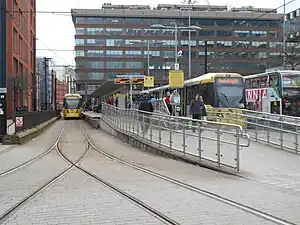 Piccadilly Gardens tram stop in February 2018 | |||||
| General information | |||||
| Location | Piccadilly Gardens, Manchester England | ||||
| Coordinates | 53°28′49″N 2°14′13″W / 53.4803°N 2.2370°W | ||||
| Grid reference | SJ843982 | ||||
| Line(s) | City Centre | ||||
| Platforms | 2 (island) | ||||
| Other information | |||||
| Status | In operation | ||||
| Fare zone | 1 | ||||
| History | |||||
| Opened | 27 April 1992 | ||||
| Original company | Metrolink | ||||
| |||||
| Location | |||||
Piccadilly Gardens is a tram stop in Zone 1 of Greater Manchester's Metrolink light rail system. It is located beside Piccadilly Gardens in Manchester city centre, and serves both as a transport hub (by integrating with the adjacent Manchester Piccadilly Gardens bus station), and interchange station (which can be used for changing between Metrolink lines).[1]
Piccadilly Gardens tram stop opened on 27 April 1992, as part of Metrolink's Phase 1. The station was rebuilt during 2009 with a wider platform and a new canopy, reopening on 2 November 2009. The stop is one of the most used on the Metrolink network.[2]
History
In 1931, a new bus station was opened on Parker Street on the former site of the Manchester Royal Infirmary, providing a central transport interchange for bus passengers.[3] In 1945, adjacent site was landscaped as an ornamental sunken garden and named Piccadilly Gardens.[4]
In 1991, construction work began on a new light rail transport network, Manchester Metrolink. New tram lines were laid along the southern and western sides of Piccadilly Gardens, and a new tram stop constructed alongside the bus station, providing an inter-modal exchange between tram and bus.[5]
Services
Service pattern
Services mostly run every 12 minutes on all routes.
At peak times (07:15 – 19:30 Monday to Friday, 09:30 – 18:30 Saturday):
- 5 trams per hour to Altrincham
- 5 trams per hour to Ashton-under-Lyne
- 5 trams per hour to Bury
- 5 trams per hour to Eccles
- 5 trams per hour to Etihad Campus
- 5 trams per hour to MediaCityUK
- 10 trams per hour to Piccadilly
Offpeak (all other times during operational hours):
- 5 trams per hour to Altrincham
- 5 trams per hour to Ashton-under-Lyne
- 5 trams per hour to Bury
- 5 trams per hour to Eccles (via MediaCityUK)
- 10 trams per hour to Piccadilly
Gallery
_-_geograph.org.uk_-_2266502.jpg.webp) Piccadilly Gardens bus station in 1976
Piccadilly Gardens bus station in 1976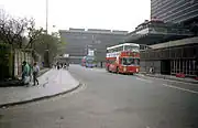 The future site of Piccadilly Gardens tram stop, photographed in 1989
 Construction of the Manchester Metrolink lines at Piccadilly Gardens in 1991
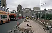 Construction of Piccadilly Gardens Metrolink platforms in 1991
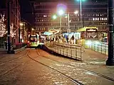 Piccadilly Gardens tram stop in December 2013.
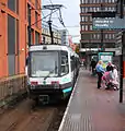 An older T-68 tram at Piccadilly Gardens tram stop in 2005.
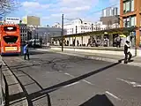 Inter-modal exchange at the bus station
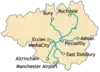
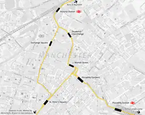 Map of Manchester City Centre Metrolink stops
References
- ↑ TfGM (2013). "Services Map" (PDF). metrolink.co.uk. Retrieved 25 February 2013.
- ↑ "Transport Statistics Greater Manchester 2017 Public Transport Section". TfGM. 5 December 2019. Retrieved 14 December 2019.
- ↑ A Hundred Years of Road Passenger Transport in Manchester. 1935. p. 30. Retrieved 6 August 2021.
- ↑ Glinert, Ed (24 April 2008). The Manchester Compendium: A Street-by-Street History of England's Greatest Industrial City. Penguin Books Limited. ISBN 978-0-14-102930-6. Retrieved 7 August 2021.
- ↑ Senior, John A.; Ogden, Eric (1992). Metrolink. Transport Publishing. ISBN 978-0-86317-155-0.
External links
| Preceding station | Following station | |||
|---|---|---|---|---|
| Market Street towards Bury |
Bury–Piccadilly | Piccadilly Terminus | ||
| St Peter's Square towards Altrincham |
Altrincham–Piccadilly | |||
| St Peter's Square towards Eccles |
Ashton-under-Lyne–Eccles via MediaCityUK | Piccadilly towards Ashton-under-Lyne | ||
| St Peter's Square towards MediaCityUK |
MediaCityUK – Ashton-under-Lyne Line | |||
Manchester railways | ||||||||||||||||||||||||||||||||||||||||||||||||||||||||||||||||||||||||||||||||||||||||||||||||||||||||||||||||||||||||||||||||||||||||||||||||||||||||||||||||||||||||||||||||||||||||||||||||||||||||||||||||||||||||||||||||||||||||||||||||||||||||||||||||||||||||||||||||||||
|---|---|---|---|---|---|---|---|---|---|---|---|---|---|---|---|---|---|---|---|---|---|---|---|---|---|---|---|---|---|---|---|---|---|---|---|---|---|---|---|---|---|---|---|---|---|---|---|---|---|---|---|---|---|---|---|---|---|---|---|---|---|---|---|---|---|---|---|---|---|---|---|---|---|---|---|---|---|---|---|---|---|---|---|---|---|---|---|---|---|---|---|---|---|---|---|---|---|---|---|---|---|---|---|---|---|---|---|---|---|---|---|---|---|---|---|---|---|---|---|---|---|---|---|---|---|---|---|---|---|---|---|---|---|---|---|---|---|---|---|---|---|---|---|---|---|---|---|---|---|---|---|---|---|---|---|---|---|---|---|---|---|---|---|---|---|---|---|---|---|---|---|---|---|---|---|---|---|---|---|---|---|---|---|---|---|---|---|---|---|---|---|---|---|---|---|---|---|---|---|---|---|---|---|---|---|---|---|---|---|---|---|---|---|---|---|---|---|---|---|---|---|---|---|---|---|---|---|---|---|---|---|---|---|---|---|---|---|---|---|---|---|---|---|---|---|---|---|---|---|---|---|---|---|---|---|---|---|---|---|---|---|---|---|---|---|---|---|---|---|---|---|---|---|---|---|---|
City Centre and North Past, present and future | ||||||||||||||||||||||||||||||||||||||||||||||||||||||||||||||||||||||||||||||||||||||||||||||||||||||||||||||||||||||||||||||||||||||||||||||||||||||||||||||||||||||||||||||||||||||||||||||||||||||||||||||||||||||||||||||||||||||||||||||||||||||||||||||||||||||||||||||||||||
| ||||||||||||||||||||||||||||||||||||||||||||||||||||||||||||||||||||||||||||||||||||||||||||||||||||||||||||||||||||||||||||||||||||||||||||||||||||||||||||||||||||||||||||||||||||||||||||||||||||||||||||||||||||||||||||||||||||||||||||||||||||||||||||||||||||||||||||||||||||
| Tram stops |
|   | ||||||||||||||||||
|---|---|---|---|---|---|---|---|---|---|---|---|---|---|---|---|---|---|---|---|---|
| Operations |
| |||||||||||||||||||
| History (Timeline) |
| |||||||||||||||||||
| Proposed developments |
| |||||||||||||||||||