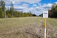

The Panmure Alvar is an alvar that lies on a limestone plain straddling the north eastern edge of Lanark County and the western boundary of the City of Ottawa, Ontario, Canada, east of the town of Pakenham.[1] In alvars, shallow soil with alternating drought and flooding conditions creates open clearings with distinctive plant and animal communities. Fire may also play a role.[2]
The forests are mostly white cedar, white spruce and poplar, with openings dominated by common juniper. The alvar clearings contain regionally significant plants such as Crawe's sedge (Carex crawei) and Hookedspur violet (Viola adunca).[1] A total of 82 native plant species have been recorded from this location, including the provincially significant Cooper's milk vetch (Astragalus neglectus).[3]
The nearest alvar is the provincially significant Burnt Lands alvar. Panmure is considered to be the second best example of limestone plain with open alvar in the Smiths Falls Plain physiographic region of site district 6-11.[3] About 725 hectares (1,790 acres) are considered as a candidate Area of Natural and Scientific Interest.[4]
The TransCanada natural gas pipeline goes through the middle of the alvar.[5]
References
- 1 2 Ontario Ministry of Natural Resources. 1991. Area of Natural and Scientific Interest - Life Science Checksheet. Page 73 in David J. White. 1992. Life Science Areas of Natural and Scientific Interest in Site District 6-11, Ontario Ministry of Natural Resources, Toronto, Ontario.
- ↑ Keddy, Paul A. 2017. Plant Ecology. Origins, Processes, Consequences. Cambridge University Press, Cambridge. ISBN 9781107114234
- 1 2 Brownell, Vivian R. and John L. Riley. 2000. The Alvars of Ontario. Significant Alvar Natural Areas in the Ontario Great Lakes Region. Federation of Ontario Naturalists, Toronto, Ontario. p 225-7. ISBN 1-896059-11-2
- ↑ "Areas of Natural and Scientific Interest (ANSI)". geohub.lio.gov.on.ca. Retrieved 27 April 2020.
- ↑ "TC Energy Canadian Mainline map - southeast section" (PDF). www.tcenergy.com. TransCanada. 28 March 2017. Retrieved 29 May 2020.