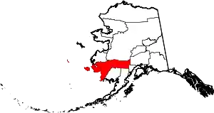
Ohagamiut (Central Yupik: Urr’agmiut) is an abandoned village along the Kuskokwim River in the Bethel Census Area of the southwestern part of the U.S. state of Alaska, located between Crow Village and Kalskag. It was abandoned in the 1940s as residents relocated to Kalskag, Aniak, Bethel and other towns. The village site is located just 3 miles east of Upper Kalskag.
Ohagamiut is sometimes confused with another Yup'ik village on the Yukon River called Ohogamiut, which is presently an Alaska Native Village Statistical Area (ANVSA).
History
Ohagamiut has also been called Okhogamute. The first reference to the village comes from Russian explorers who traveled down the Kuskokwim River in 1818.[1] The first Roman Catholic mission in western Alaska was established at Ohagamiut in 1892. The first census of Alaska completed in 1884 by Ivan Petrof showed Okhogamute having a population of 130.[2]
Demographics
| Census | Pop. | Note | %± |
|---|---|---|---|
| 1880 | 130 | — | |
| 1890 | 36 | −72.3% | |
| 1920 | 92 | — | |
| U.S. Decennial Census[3] | |||
Ohagamiut first reported on the 1880 U.S. Census as the unincorporated Yup'ik village of "Okhogamute", with 130 residents (127 Inuit and 3 Creole (Mixed Russian and Native)).[4][5] It returned in 1890 as "Oh-hagamiut", with 36 residents (all Native).[6] It last appeared on the 1920 census as "Ohagamute", with 92 residents. Although it never appeared on the census again, it would later appear on maps as "Oknagamut."[7]
Notes
- ↑ "Cultural Resources Report: Kuskokwim River Resources Management Mapping Project" (PDF). State of Alaska Department of Natural Resources. December 1985. Archived from the original (PDF) on February 8, 2006. Retrieved June 22, 2006.
- ↑ Petrof, Ivan, (1884). "Report on the Population, Industries, and Resources of Alaska" Reprinted from U.S. 10th Census, Reports [1880] Washington, U.S. Census Office
- ↑ "U.S. Decennial Census". Census.gov. Retrieved June 6, 2013.
- ↑ "Statistics of the Population of Alaska" (PDF). United States Census Bureau. 1880.
- ↑ "Geological Survey Professional Paper". 1949.
- ↑ "Report on Population and Resources of Alaska at the Eleventh Census: 1890" (PDF). United States Census Bureau. Government Printing Office.
- ↑ "Get Maps | topoView".
61°32′14″N 160°11′52″W / 61.537196417932485°N 160.19766944016726°W
