Metylovice | |
|---|---|
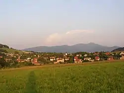
 View from the northwest | |
 Flag  Coat of arms | |
 Metylovice Location in the Czech Republic | |
| Coordinates: 49°36′24″N 18°20′21″E / 49.60667°N 18.33917°E | |
| Country | |
| Region | Moravian-Silesian |
| District | Frýdek-Místek |
| First mentioned | 1299 |
| Government | |
| • Mayor | Lukáš Halata |
| Area | |
| • Total | 11.15 km2 (4.31 sq mi) |
| Elevation | 370 m (1,210 ft) |
| Population (2023-01-01)[1] | |
| • Total | 1,825 |
| • Density | 160/km2 (420/sq mi) |
| Time zone | UTC+1 (CET) |
| • Summer (DST) | UTC+2 (CEST) |
| Postal code | 739 49 |
| Website | metylovice |
Metylovice (German: Mettilowitz, in 1939–1945 Quittendorf) is a municipality and village in Frýdek-Místek District in the Moravian-Silesian Region of the Czech Republic. It has about 1,800 inhabitants.
Geography
Metylovice is located about 7 kilometres (4 mi) south of Frýdek-Místek and 21 km (13 mi) south of Ostrava. It lies in the Moravian-Silesian Foothills. The highest point is the Ondřejník mountain at 890 m (2,920 ft) above sea level. The Olešná Stream flows through the municipality.
History
The first written mention of Metylovice is in a deed of Bishop Dětřich from 1299. From the second half of the 17th century, tanning developed in the village, thanks to which the originally agricultural village began to prosper and grow. Brick houses began to replace the original wooden ones and the education and cultural life of the inhabitants increased.[2]
Sights
The most important monument is the Church of All Saints. It was built in Gothic style in 1577 on the site of an older wooden church, and later baroque modified.[2]
Twin towns – sister cities
Metylovice is twinned with:[3]
 Krásno nad Kysucou, Slovakia
References
- ↑ "Population of Municipalities – 1 January 2023". Czech Statistical Office. 2023-05-23.
- 1 2 "Historie obce" (in Czech). Obec Metylovice. Retrieved 2023-05-30.
- ↑ "Partnerské mestá" (in Slovak). Krásno nad Kysucou. Retrieved 2020-09-22.