Mark Landin | |
|---|---|
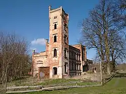 Castle Hohenlandin | |
Location of Mark Landin | |
 Mark Landin  Mark Landin | |
| Coordinates: 53°05′00″N 14°08′00″E / 53.0833°N 14.1333°E | |
| Country | Germany |
| State | Brandenburg |
| District | Uckermark |
| Disbanded | 2022 |
| Area | |
| • Total | 44.27 km2 (17.09 sq mi) |
| Elevation | 45 m (148 ft) |
| Population (2020-12-31) | |
| • Total | 962 |
| • Density | 22/km2 (56/sq mi) |
| Time zone | UTC+01:00 (CET) |
| • Summer (DST) | UTC+02:00 (CEST) |
| Postal codes | 16278 |
| Dialling codes | 033335, 033336 |
| Vehicle registration | UM |
Mark Landin is a former municipality in the Uckermark district, in Brandenburg, Germany. It was merged into the town Schwedt on 19 April 2022.[1] It consisted of the villages Grünow, Landin and Schönermark, which became Ortsteile of Schwedt.
Demography
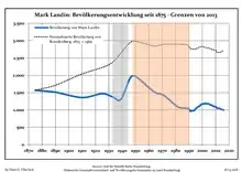
Development of Population since 1875 within the Current Boundaries (Blue Line: Population; Dotted Line: Comparison to Population Development of Brandenburg state; Grey Background: Time of Nazi rule; Red Background: Time of Communist rule)
|
|
|
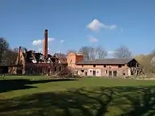
Former distillery
References
- ↑ Gesetz über die Gebietsänderung der amtsangehörigen Gemeinden des Amtes Oder-Welse, Berkholz-Meyenburg, Mark Landin, Passow und Pinnow (Uckermark), Gesetz- und Verordnungsblatt für das Land Brandenburg, 25 March 2022.
- ↑ Detailed data sources are to be found in the Wikimedia Commons.Population Projection Brandenburg at Wikimedia Commons
Wikimedia Commons has media related to Mark Landin.
This article is issued from Wikipedia. The text is licensed under Creative Commons - Attribution - Sharealike. Additional terms may apply for the media files.