Manzanita, California | |
|---|---|
 Manzanita  Manzanita | |
| Coordinates: 32°40′08″N 116°17′23″W / 32.66889°N 116.28972°W | |
| Country | |
| State | |
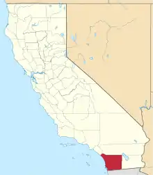
| County | |
| Elevation | 1,069 m (3,507 ft) |
| Time zone | UTC-8 (Pacific (PST)) |
| • Summer (DST) | UTC-7 (PDT) |
| Area code(s) | 619 & 858 |
| GNIS feature ID | 245461[1] |
Manzanita (Spanish for "little apple") is an unincorporated community in San Diego County, California, United States. The community is at the junction of Interstate 8 and California State Route 94 17.5 miles (28.2 km) southeast of Pine Valley.[2]
References
- ↑ "Manzanita". Geographic Names Information System. United States Geological Survey, United States Department of the Interior.
- ↑ California Department of Transportation (2005). State Highway Map 2005 (Map). Retrieved June 7, 2019 – via David Rumsey Historical Map Collection.
This article is issued from Wikipedia. The text is licensed under Creative Commons - Attribution - Sharealike. Additional terms may apply for the media files.