Mandailing Natal Regency
(Kabupaten Mandailing Natal) | |
|---|---|
 Coat of arms | |
 | |
| Country | Indonesia |
| Province | North Sumatra |
| Regency seat | Panyabungan |
| Government | |
| • Regent | Dahlan Hasan Nasution |
| • Vice Regent | Muhammad Jafar Sukhairi Nasution |
| • Chairman of Council of Representatives | Erwin Efendi Lubis (Gerindra) |
| • Vice Chairmen of Council of Representatives | Harminsyah Batubara (Partai Demokrat) and Erwin Efendi Nasution (Golkar) |
| Area | |
| • Total | 6,620.70 km2 (2,556.27 sq mi) |
| Population (mid 2022 estimate)[1] | |
| • Total | 484,874 |
| • Density | 73/km2 (190/sq mi) |
| Time zone | UTC+7 (WIB) |
| Website | www |
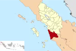
Mandailing Natal, abbreviated as Madina, is a regency in North Sumatra Province of Indonesia. It covers an area of 6,620.70 square kilometres and it had a population of 403,894 people at the 2010 census[2] and 472,886 at the 2020 Census;[3] the official estimate as at mid 2022 was 484,874.[1] The capital lies at Panyabungan. The Regency was formerly a part of South Tapanuli Regency until it was created as a separate regency on 23 November 1998. It is the southernmost regency in North Sumatra, and the largest regency by land area in the province, with Langkat Regency second to it.
Geography
The regency is divided in two by the Bukit Barisan mountains. The portion to the west of the mountains drains to the west coast of Sumatra, and comprises the districts of Batahan, Sinunukan, Batang Natal, Lingga Bayu, Ranto Baek, Natal and Muara Batang Gadis; it covers an area of 4,057 km2, and had a population of 173,758 in mid 2022.[1] The portion to the east of the mountains comprises the remaining districts of the Regency, all of which drain towards the north; it covers an area of 2,563.7 km2 and had a population of 311,116 in mid 2022.
Administration
At the 2010 Census, the regency was divided into eighteen districts (kecamatan). Subsequently, five additional districts (indicated by asterisks in the table below) have been created by the division of existing districts. The twenty-three districts are tabulated below with their areas and their population at the 2010 Census[2] and the 2020 Census,[3] together with the official estimates as at mid 2022.[1] The table also includes the locations of the district administrative centres, the number of administrative villages in each district (totaling 377 rural desa and 27 urban kelurahan), and its post code.
| Kode Wilayah | Name of District (kecamatan) | Area in km2 | Pop'n Census 2010 | Pop'n Census 2020 | Pop'n Estimate mid 2022 | Admin centre | No. of villages | Post code |
|---|---|---|---|---|---|---|---|---|
| 12.13.15 | Batahan | 497.07 | 17,524 | 22,509 | 23,427 | Pasar Batahan | 18 (a) | 22988 |
| 12.13.22 | Sinunukan * | 192.64 | 15,375 | 21,527 | 22,782 | Sinunukan III | 14 | 22986 |
| 12.13.13 | Batang Natal | 651.52 | 22,575 | 25,333 | 25,685 | Muara Soma | 31 (a) | 22983 |
| 12.13.14 | Lingga Bayu | 192.68 | 22,453 | 27,576 | 28,452 | Simpang Gambir | 19 (b) | 22982 |
| 12.13.18 | Ranto Baek * | 152.72 | 11,259 | 14,085 | 14,585 | Manisak | 17 | 22984 |
| 12.13.08 | Kotanopan | 325.15 | 26,264 | 27,871 | 28,024 | Pasar Kotanopan | 36 (b) | 22994 |
| 12.13.11 | Ulu Pungkut | 295.19 | 4,250 | 4,674 | 4,721 | Huta Godang | 13 (a) | 22999 |
| 12.13.10 | Tambangan | 158.60 | 11,471 | 10,913 | 11,058 | Laru Lombang | 20 (a) | 22996 |
| 12.13.09 | Lembah Sorik Marapi | 34.73 | 15,605 | 10,968 | 11,116 | Pasar Maga | 9 (a) | 22993 |
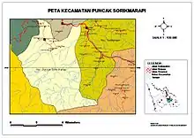
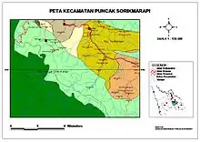
| 12.13.20 | Puncak Sorik Marapi * | 55.54 | 7,954 | 8,975 | 9,110 | Sibanggor | 11 | 22995 |
| 12.13.12 | Muara Sipongi | 135.70 | 9,670 | 12,528 | 12,873 | Pasar Muara Sipongi | 16 (a) | 22998 |
| 12.13.21 | Pakantan * | 93.60 | 2,146 | 2,222 | 2,243 | Pakantan | 8 | 22997 |
| 12.13.01 | Panyabungan Kota | 259.77 | 77,449 | 90,049 | 91,929 | Panyabungan | 39 (c) | 22915 -22919 |
| 12.13.04 | Panyabungan Selatan (South Panyabungan) | 87.60 | 9,410 | 10,323 | 10,421 | Tano Bato | 11 (a) | 22952 |
| 12.13.05 | Panyabungan Barat (West Panyabungan) | 87.22 | 8,911 | 10,677 | 10,964 | Longat | 10 (a) | 22911 |
| 12.13.02 | Panyabungan Utara (North Panyabungan) | 63.73 | 19,991 | 22,573 | 22,915 | Mompang | 12 (a) | 22979 |
| 12.13.03 | Panyabungan Timur (East Panyabungan) | 397.87 | 12,307 | 14,214 | 14,492 | Gunung Baringin | 15 (a) | 22912 |
| 12.13.19 | Huta Bargot * | 116.21 | 5,715 | 8,748 | 9,062 | Bangun Sejati | 12 | 22978 |
| 12.13.16 | Natal | 935.37 | 27,292 | 33,897 | 35,050 | Pasar Natal | 30 (b) | 22987 |
| 12.13.17 | Muara Batang Gadis | 1,435.02 | 15,416 | 22,322 | 23,777 | Singkuang | 14 | 22989 |
| 12.13.06 | Siabu | 345.36 | 47,364 | 53,286 | 54,054 | Siabu | 28 (b) | 22976 |
| 12.13.07 | Bukit Malintang | 68.74 | 10,894 | 12,771 | 13,059 | Bukit Malintang | 11 | 22977 |
| 12.13.23 | Naga Juang * | 58.69 | 3,650 | 4,845 | 5,075 | Banua Simanosor | 7 | 22975 |
| Totals | 6,640.72 | 404,945 | 472,886 | 484,874 | Panyabungan | 404 |
Notes: (a) including 1 kelurahan. (b) including 2 kelurahan. (c) comprising 9 kelurahan and 30 desa.
National Park
see Batang Gadis National Park