Louisiana Highway 35 | ||||
|---|---|---|---|---|
 | ||||
| Route information | ||||
| Maintained by Louisiana DOTD | ||||
| Length | 52.152 mi[1] (83.931 km) | |||
| Existed | 1955 renumbering–present | |||
| Major junctions | ||||
| South end | ||||
| North end | ||||
| Location | ||||
| Country | United States | |||
| State | Louisiana | |||
| Parishes | Vermilion, Lafayette, Acadia, St. Landry | |||
| Highway system | ||||
| ||||
| ||||
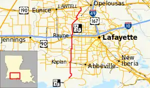
Louisiana Highway 35 (LA 35) is a 52.3 miles (84.2 km)-long north-south state highway in Louisiana that serves Vermilion, Lafayette, Acadia, and Saint Landry parishes, extending from Louisiana Highway 82, intersecting with exit 87 of Interstate 10, ending at US Route 190.[2]
Route description
From the south, LA 35 begins at a junction with LA 82 located just north of the Gulf Intracoastal Waterway and an area known as Forked Island. The route heads northward and crosses LA 14 in the city of Kaplan. North of Kaplan, LA 35 briefly overlaps LA 92 to the west of Indian Bayou. About 7 miles (11 km) later, LA 35 passes through the city of Rayne, where it runs concurrent with US 90 through the center of town. After US 90 departs to the east, LA 35 passes through a diamond interchange with I-10 (exit 87) at the north end of town. This interchange is followed immediately by a junction with LA 98. Continuing northward, LA 35 passes through the rural community of Branch en route to the town of Church Point. The route zigzags through the center of town, overlapping the route of LA 95. North of Church Point, LA 35 meanders into St. Landry Parish and reaches its northern terminus at US 190 in Lawtell.[2]
History
Prior to the 1955 Louisiana Highway renumbering, LA 35 was a road from Amite to Bogalusa via Franklinton. In 1955 the Amite-to-Franklinton segment became part of LA 16, and the Franklinton-to-Bogalusa segment became part of LA 10.
Major intersections
| Parish | Location | mi[1] | km | Destinations | Notes | |||
|---|---|---|---|---|---|---|---|---|
| Vermilion | | 0.000 | 0.000 | Southern terminus; 1.0 mile (1.6 km) north of Forked Island | ||||
| | 8.215 | 13.221 | ||||||
| | 11.433 | 18.400 | Eastern terminus of LA 708 | |||||
| Kaplan | 11.862 | 19.090 | ||||||
| 13.848 | 22.286 | Western terminus of LA 696 | ||||||
| | 14.832 | 23.870 | Southern terminus of LA 700 | |||||
| | 17.878 | 28.772 | ||||||
| | 19.904 | 32.032 | South end of LA 92 concurrency | |||||
| | 20.924 | 33.674 | Eastern terminus of LA 705 | |||||
| | 21.434 | 34.495 | North end of LA 92 concurrency | |||||
| Lafayette |
No major junctions | |||||||
| Acadia | | 24.614 | 39.612 | Western terminus of LA 342 | ||||
| Rayne | 28.549 | 45.945 | South end of US 90 concurrency | |||||
| 29.129 | 46.879 | North end of US 90 concurrency; eastern terminus of LA 3076 | ||||||
| 29.620 | 47.669 | South end of LA 98 concurrency | ||||||
| 30.265– 30.403 | 48.707– 48.929 | Exit 87 on I-10 | ||||||
| 30.429 | 48.971 | North end of LA 98 concurrency | ||||||
| | 36.326 | 58.461 | Western terminus of LA 1102 | |||||
| Branch | 37.249 | 59.946 | ||||||
| | 40.764 | 65.603 | Eastern terminus of LA 370 | |||||
| Church Point | 42.239 | 67.977 | South end of LA 95 concurrency | |||||
| 42.561 | 68.495 | North end of LA 95 concurrency | ||||||
| Acadia–St. Landry parish line | | 45.083 | 72.554 | Southern terminus of LA 751 | ||||
| St. Landry | | 47.528 | 76.489 | |||||
| | 51.336 | 82.617 | Eastern terminus of LA 752 | |||||
| Lawtell | 52.087– 52.152 | 83.826– 83.931 | Northern terminus; one-way pair | |||||
1.000 mi = 1.609 km; 1.000 km = 0.621 mi
| ||||||||
References
- 1 2 "La DOTD GIS Data". Louisiana Department of Transportation and Development. September 2015. Retrieved August 21, 2016.
- 1 2 Google (August 21, 2016). "Overview Map of LA 35" (Map). Google Maps. Google. Retrieved August 21, 2016.
.svg.png.webp)