| Littleton Formation | |
|---|---|
| Stratigraphic range: Devonian | |
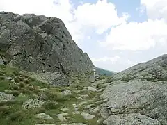 The Littleton Formation in Sphinx Col between Mount Jefferson and Mount Clay in the Presidential Range of New Hampshire | |
| Type | Formation |
| Location | |
| Region | |
| Country | |
The Littleton Formation is a geologic formation in New Hampshire. It preserves fossils dating back to the Devonian period. The formation is exposed on several of New Hampshire's most prominent mountains, including Mount Washington and the northern Presidential Range, Mount Moosilauke, and Mount Monadnock.[1]
See also
References
- ↑ "New Hampshire geologic map data". U.S. Geological Survey. Retrieved January 5, 2015.
- Various Contributors to the Paleobiology Database. "Fossilworks: Gateway to the Paleobiology Database". Retrieved 17 December 2021.
This article is issued from Wikipedia. The text is licensed under Creative Commons - Attribution - Sharealike. Additional terms may apply for the media files.