| Little Sewickley Creek Tributary to Sewickley Creek | |
|---|---|
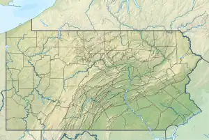 Location of Little Sewickley Creek mouth  Little Sewickley Creek (the United States) | |
| Location | |
| Country | United States |
| State | Pennsylvania |
| County | Westmoreland |
| Borough | Herminie Arona |
| Physical characteristics | |
| Source | Brush Creek divide |
| • location | about 0.5 miles east of Lincoln Heights, Pennsylvania[1] |
| • coordinates | 40°18′41″N 079°36′14″W / 40.31139°N 79.60389°W[2] |
| • elevation | 1,260 ft (380 m)[1] |
| Mouth | Sewickley Creek |
• location | Cowansburg, Pennsylvania[3] |
• coordinates | 40°15′02″N 079°45′37″W / 40.25056°N 79.76028°W[2] |
• elevation | 758 ft (231 m)[3] |
| Length | 13.42 mi (21.60 km)[4] |
| Basin size | 30.79 square miles (79.7 km2)[5] |
| Discharge | |
| • location | Sewickley Creek |
| • average | 36.61 cu ft/s (1.037 m3/s) at mouth with Sewickley Creek[5] |
| Basin features | |
| Progression | Sewickley Creek → Youghiogheny River → Monongahela River → Ohio River → Mississippi River → Gulf of Mexico |
| River system | Monongahela River |
| Tributaries | |
| • left | unnamed tributaries |
| • right | Andrews Run |
| Bridges | Walton Tea Room Road, PA 66, Marwood Forest Road, Walton Tea Room Road, Baughman Hollow Road, PA 66, PA 136, Whigham Road, Kocevar Lane, Rocky Mountain Road, Arona Road, I-76, Ladysmith Road, PA 136, Lash Road, Keystone Road, High Street, Clay Pike, Greenhills Road, Lowber Road (x3) |
Little Sewickley Creek is a 13.42 mi (21.60 km) long 3rd order tributary to Sewickley Creek in Westmoreland County, Pennsylvania.
Course
Little Sewickley Creek rises about 0.5 miles east of Lincoln Heights, Pennsylvania,[1] and then flows west to join Sewickley Creek at Cowansburg, Pennsylvania.[3]
Watershed
Little Seiwckley Creek drains 30.79 square miles (79.7 km2) of area, receives about 40.7 in/year of precipitation, has a wetness index of 343.54, and is about 49% forested.[5]
See also
References
- 1 2 3 "Get Maps". USGS Topoview. US Geological Survey. Retrieved 18 November 2020.
- 1 2 "GNIS Detail - Little Sewickley Creek". geonames.usgs.gov. US Geological Survey. Retrieved 18 November 2020.
- 1 2 3 "Get Maps". USGS Topoview. US Geological Survey. Retrieved 18 November 2020.
- ↑ "ArcGIS Web Application". epa.maps.arcgis.com. US EPA. Retrieved 18 November 2020.
- 1 2 3 "Little Sewickley Creek Watershed Report". US EPA Geoviewer. US EPA. Retrieved 18 November 2020.
This article is issued from Wikipedia. The text is licensed under Creative Commons - Attribution - Sharealike. Additional terms may apply for the media files.