Le Cloître-Saint-Thégonnec
Ar C'hloastr-Plourin | |
|---|---|
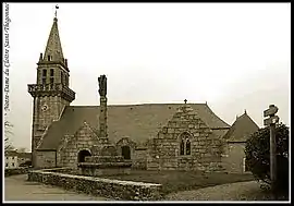 Notre-Dame of the Cloître Saint-Thégonnec | |
Location of Le Cloître-Saint-Thégonnec | |
 Le Cloître-Saint-Thégonnec  Le Cloître-Saint-Thégonnec | |
| Coordinates: 48°28′51″N 3°47′36″W / 48.4808°N 3.7933°W | |
| Country | France |
| Region | Brittany |
| Department | Finistère |
| Arrondissement | Morlaix |
| Canton | Plouigneau |
| Intercommunality | Morlaix Communauté |
| Government | |
| • Mayor (2020–2026) | Jean-René Péron[1] |
| Area 1 | 28.48 km2 (11.00 sq mi) |
| Population | 649 |
| • Density | 23/km2 (59/sq mi) |
| Time zone | UTC+01:00 (CET) |
| • Summer (DST) | UTC+02:00 (CEST) |
| INSEE/Postal code | 29034 /29410 |
| Elevation | 100–300 m (330–980 ft) |
| 1 French Land Register data, which excludes lakes, ponds, glaciers > 1 km2 (0.386 sq mi or 247 acres) and river estuaries. | |
Le Cloître-Saint-Thégonnec (French pronunciation: [lə klwatʁ sɛ̃ teɡɔnɛk]; Breton: Ar C'hloastr-Plourin) is a commune in the Finistère department of Brittany in north-western France.
Population
| Year | Pop. | ±% p.a. |
|---|---|---|
| 1968 | 566 | — |
| 1975 | 518 | −1.26% |
| 1982 | 561 | +1.15% |
| 1990 | 566 | +0.11% |
| 1999 | 569 | +0.06% |
| 2009 | 617 | +0.81% |
| 2014 | 669 | +1.63% |
| 2020 | 653 | −0.40% |
| Source: INSEE[3] | ||
Inhabitants of Le Cloître-Saint-Thégonnec are called in French Cloîtriens.
See also
References
- ↑ "Répertoire national des élus: les maires" (in French). data.gouv.fr, Plateforme ouverte des données publiques françaises. 13 September 2022.
- ↑ "Populations légales 2021". The National Institute of Statistics and Economic Studies. 28 December 2023.
- ↑ Population en historique depuis 1968, INSEE
External links
Wikimedia Commons has media related to Le Cloître-Saint-Thégonnec.
- Base Mérimée: Search for heritage in the commune, Ministère français de la Culture. (in French)
- Mayors of Finistère Association (in French)
This article is issued from Wikipedia. The text is licensed under Creative Commons - Attribution - Sharealike. Additional terms may apply for the media files.