Lawn, Pennsylvania | |
|---|---|
Unincorporated community | |
 Lawn  Lawn | |
| Coordinates: 40°13′12″N 76°32′21″W / 40.22000°N 76.53917°W | |
| Country | United States |
| State | Pennsylvania |
| County | Lebanon |
| Township | South Londonderry |
| Elevation | 479 ft (146 m) |
| Time zone | UTC-5 (Eastern (EST)) |
| • Summer (DST) | UTC-4 (EDT) |
| ZIP code | 17041 |
| Area code | 717 |
| GNIS feature ID | 1179046[1] |
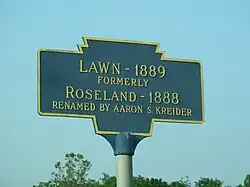
Lawn, previously known as Roseland, is an unincorporated community in South Londonderry Township in Lebanon County, Pennsylvania, United States. Lawn is located at the intersection of Pennsylvania Route 241 and Lawn Road.[2]
References
- ↑ "Lawn". Geographic Names Information System. United States Geological Survey, United States Department of the Interior.
- ↑ Lebanon County, Pennsylvania Highway Map (PDF) (Map). PennDOT. 2012. Retrieved September 3, 2013.
External links
 Media related to Lawn, Pennsylvania at Wikimedia Commons
Municipalities and communities of Lebanon County, Pennsylvania, United States | ||
|---|---|---|
| City | 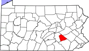 | |
| Boroughs | ||
| Townships | ||
| CDPs | ||
| Unincorporated communities | ||
This article is issued from Wikipedia. The text is licensed under Creative Commons - Attribution - Sharealike. Additional terms may apply for the media files.