Langenes Municipality
Langenes herred | |
|---|---|
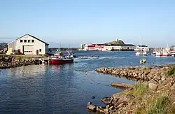 View of the village harbour of Stø | |
 Nordland within Norway | |
 Langenes within Nordland | |
| Coordinates: 69°01′07″N 15°09′21″E / 69.01861°N 15.15583°E | |
| Country | Norway |
| County | Nordland |
| District | Vesterålen |
| Established | 1 Jan 1919 |
| • Preceded by | Øksnes Municipality |
| Disestablished | 1 Jan 1964 |
| • Succeeded by | Øksnes Municipality |
| Administrative centre | Stø |
| Area (upon dissolution) | |
| • Total | 103 km2 (40 sq mi) |
| Population (1964) | |
| • Total | 2,037 |
| • Density | 20/km2 (51/sq mi) |
| Demonyms | Langnesfjerding Langenesfjerding[1] |
| Time zone | UTC+01:00 (CET) |
| • Summer (DST) | UTC+02:00 (CEST) |
| ISO 3166 code | NO-1869[2] |
Langenes is a former municipality in Nordland county, Norway. The municipality, which existed from 1919 until 1964, encompassed the western shore of the Gavlfjorden in what is now Øksnes Municipality. It is located on the northern end of the large island of Langøya in the Vesterålen archipelago. The administrative centre was in the village of Stø, just east of the Langenes Church in the northern part of the municipality.[3]
History
The municipality of Langenes was established on 1 July 1919 when the northeastern part of Øksnes Municipality was split off from Øksnes to form the new municipality. Initially, Langenes had a population of 1,085. During the 1960s, there were many municipal mergers across Norway due to the work of the Schei Committee. On 1 January 1963, the Holm area along the Gavlfjorden (population: 65) was transferred from Langenes to Sortland Municipality. On 1 January 1964, the rest of Langenes (population: 2,037) was merged back together with Øksnes. Prior to the merger, Langenes had 2,037 residents.[4]
Name
The municipality is named after the old Langenes farm (Old Norse: Langøyjarnes) since the first Langenes Church was built there. The first element is lang which means "long", here referring to the island, Langøya on which the municipality was located. The island's name, Langøya, is directly translated as "the long island". The last element is nes which means "headland". The municipality was located on the northernmost peninsula on the island thus the name Langenes means the "headland on Langøya".[5]
Government
While it existed, this municipality was responsible for primary education (through 10th grade), outpatient health services, senior citizen services, unemployment, social services, zoning, economic development, and municipal roads. During its existence, this municipality was governed by a municipal council of elected representatives, which in turn elected a mayor.[6]
Municipal council
The municipal council (Herredsstyre) of Langenes was made up of representatives that were elected to four year terms. The party breakdown of the final municipal council was as follows:
| Party name (in Norwegian) | Number of representatives | |
|---|---|---|
| Labour Party (Arbeiderpartiet) | 5 | |
| Christian Democratic Party (Kristelig Folkeparti) | 4 | |
| List of workers, fishermen, and small farmholders (Arbeidere, fiskere, småbrukere liste) | 1 | |
| Joint List(s) of Non-Socialist Parties (Borgerlige Felleslister) | 3 | |
| Total number of members: | 13 | |
| Party name (in Norwegian) | Number of representatives | |
|---|---|---|
| Labour Party (Arbeiderpartiet) | 7 | |
| Christian Democratic Party (Kristelig Folkeparti) | 3 | |
| Joint List(s) of Non-Socialist Parties (Borgerlige Felleslister) | 2 | |
| Local List(s) (Lokale lister) | 1 | |
| Total number of members: | 13 | |
| Party name (in Norwegian) | Number of representatives | |
|---|---|---|
| Labour Party (Arbeiderpartiet) | 5 | |
| Conservative Party (Høyre) | 2 | |
| Christian Democratic Party (Kristelig Folkeparti) | 4 | |
| Liberal Party (Venstre) | 1 | |
| Total number of members: | 12 | |
| Party name (in Norwegian) | Number of representatives | |
|---|---|---|
| Local List(s) (Lokale lister) | 12 | |
| Total number of members: | 12 | |
| Party name (in Norwegian) | Number of representatives | |
|---|---|---|
| Local List(s) (Lokale lister) | 12 | |
| Total number of members: | 12 | |
| Party name (in Norwegian) | Number of representatives | |
|---|---|---|
| Local List(s) (Lokale lister) | 12 | |
| Total number of members: | 12 | |
| Note: Due to the German occupation of Norway during World War II, no elections were held for new municipal councils until after the war ended in 1945. | ||
See also
References
- ↑ "Navn på steder og personer: Innbyggjarnamn" (in Norwegian). Språkrådet.
- ↑ Bolstad, Erik; Thorsnæs, Geir, eds. (26 January 2023). "Kommunenummer". Store norske leksikon (in Norwegian). Kunnskapsforlaget.
- ↑ Store norske leksikon. "Langenes" (in Norwegian). Retrieved 1 August 2012.
- ↑ Jukvam, Dag (1999). Historisk oversikt over endringer i kommune- og fylkesinndelingen (PDF) (in Norwegian). Statistisk sentralbyrå. ISBN 9788253746845.
- ↑ Rygh, Oluf (1905). Norske gaardnavne: Nordlands amt (in Norwegian) (16 ed.). Kristiania, Norge: W. C. Fabritius & sønners bogtrikkeri. p. 389.
- ↑ Hansen, Tore; Vabo, Signy Irene, eds. (20 September 2022). "kommunestyre". Store norske leksikon (in Norwegian). Kunnskapsforlaget. Retrieved 1 January 2023.
- ↑ "Kommunevalgene og Ordførervalgene 1959" (PDF) (in Norwegian). Oslo: Statistisk sentralbyrå. 1960. Retrieved 18 March 2020.
- ↑ "Kommunevalgene og Ordførervalgene 1955" (PDF) (in Norwegian). Oslo: Statistisk sentralbyrå. 1957. Retrieved 18 March 2020.
- ↑ "Kommunevalgene og Ordførervalgene 1951" (PDF) (in Norwegian). Oslo: Statistisk sentralbyrå. 1952. Retrieved 18 March 2020.
- ↑ "Kommunevalgene og Ordførervalgene 1947" (PDF) (in Norwegian). Oslo: Statistisk sentralbyrå. 1948. Retrieved 18 March 2020.
- ↑ "Kommunevalgene og Ordførervalgene 1945" (PDF) (in Norwegian). Oslo: Statistisk sentralbyrå. 1947. Retrieved 18 March 2020.
- ↑ "Kommunevalgene og Ordførervalgene 1937" (PDF) (in Norwegian). Oslo: Statistisk sentralbyrå. 1938. Retrieved 18 March 2020.
| |||||||||||
 | Towns and cities |
| |||||||||
| Municipalities |
| ||||||||||
| |||||||||||