Langarud County
Persian: شهرستان لنگرود | |
|---|---|
County | |
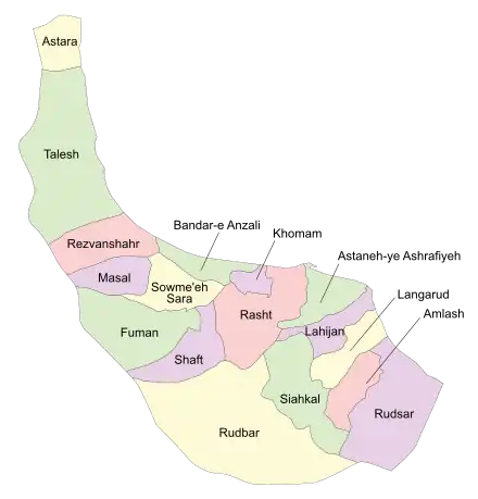 Location of Langarud County in Gilan province (right, yellow) | |
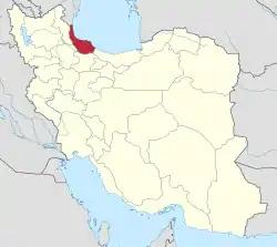 Location of Gilan province in Iran | |
| Coordinates: 37°07′N 50°08′E / 37.117°N 50.133°E[1] | |
| Country | |
| Province | Gilan |
| Capital | Langarud |
| Districts | Central, Kumeleh, Otaqvar |
| Population (2016)[2] | |
| • Total | 140,686 |
| Time zone | UTC+3:30 (IRST) |
| Langarud County can be found at GEOnet Names Server, at this link, by opening the Advanced Search box, entering "9207025" in the "Unique Feature Id" form, and clicking on "Search Database". | |
Langarud County (Persian: شهرستان لنگرود) is in Gilan province, Iran. Its capital is the city of Langarud.[3]
At the 2006 census, the county's population was 133,133 in 38,597 households.[4] The following census in 2011 counted 137,272 people in 44,344 households.[5] At the 2016 census, the county's population was 140,686 in 49,351 households.[2]
Administrative divisions
The population history of Langarud County's administrative divisions over three consecutive censuses is shown in the following table. The latest census shows three districts, seven rural districts, and five cities.[2]
| Administrative Divisions | 2006[4] | 2011[5] | 2016[2] |
|---|---|---|---|
| Central District | 90,729 | 99,021 | 103,282 |
| Chaf RD | 9,834 | 6,961 | 2,395 |
| Divshal RD | 10,179 | 10,313 | 10,261 |
| Gel-e Sefid RD | 5,347 | 2,776 | 2,341 |
| Chaf and Chamkhaleh (city)1 | 4,494 | 8,840 | |
| Langarud (city) | 65,369 | 74,477 | 79,445 |
| Kumeleh District | 27,394 | 24,925 | 24,630 |
| Daryasar RD | 10,508 | 8,264 | 8,638 |
| Moridan RD | 5,532 | 5,399 | 4,433 |
| Kumeleh (city) | 5,703 | 6,078 | 6,457 |
| Shalman (city) | 5,651 | 5,184 | 5,102 |
| Otaqvar District | 15,010 | 13,326 | 12,774 |
| Lat Leyl RD | 5,119 | 4,387 | 4,039 |
| Otaqvar RD | 8,487 | 7,135 | 6,797 |
| Otaqvar (city) | 1,404 | 1,804 | 1,938 |
| Total | 133,133 | 137,272 | 140,686 |
| RD: Rural District 1Merger of several villages[6] | |||
Wikimedia Commons has media related to Langarud County.
References
- ↑ OpenStreetMap contributors (5 October 2023). "Langarud County" (Map). OpenStreetMap. Retrieved 5 October 2023.
- 1 2 3 4 "Census of the Islamic Republic of Iran, 1395 (2016)". AMAR (in Persian). The Statistical Center of Iran. p. 01. Archived from the original (Excel) on 4 December 2020. Retrieved 19 December 2022.
- ↑ Habibi, Hassan (21 June 1369). "Approval of the organization and chain of citizenship of the elements and units of the national divisions of Gilan province centered on the city of Rasht". Islamic Parliament Research Center (in Persian). Ministry of Interior, Defense Political Commission of the Government Board. Archived from the original on 12 October 2016. Retrieved 12 December 2023.
- 1 2 "Census of the Islamic Republic of Iran, 1385 (2006)". AMAR (in Persian). The Statistical Center of Iran. p. 01. Archived from the original (Excel) on 20 September 2011. Retrieved 25 September 2022.
- 1 2 "Census of the Islamic Republic of Iran, 1390 (2011)". Syracuse University (in Persian). The Statistical Center of Iran. p. 01. Archived from the original (Excel) on 8 October 2023. Retrieved 19 December 2022.
- ↑ Rahimi, Mohammad Reza (18 May 1388). "Divisional changes and reforms in Gilan province". Qavanin (in Persian). Ministry of Interior, Defense Politcal Commission. Archived from the original on 5 October 2023. Retrieved 5 October 2023.
| Capital |  | |
|---|---|---|
| Counties and cities | ||
| Sights |
| |
| Populated places | ||
This article is issued from Wikipedia. The text is licensed under Creative Commons - Attribution - Sharealike. Additional terms may apply for the media files.