| Lammermoor Queensland | |||||||||||||||
|---|---|---|---|---|---|---|---|---|---|---|---|---|---|---|---|
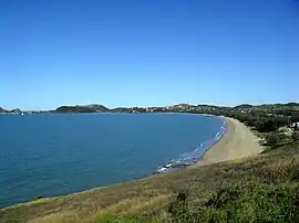
 Lammermoor Beach, looking south from Wreck Point, 2011 | |||||||||||||||
 Lammermoor | |||||||||||||||
| Coordinates | 23°09′22″S 150°46′21″E / 23.1561°S 150.7725°E | ||||||||||||||
| Population | 2,167 (2016 census)[1] | ||||||||||||||
| • Density | 202.5/km2 (524.5/sq mi) | ||||||||||||||
| Postcode(s) | 4703 | ||||||||||||||
| Area | 10.7 km2 (4.1 sq mi) | ||||||||||||||
| Time zone | AEST (UTC+10:00) | ||||||||||||||
| Location |
| ||||||||||||||
| LGA(s) | Shire of Livingstone | ||||||||||||||
| Region | Central Queensland | ||||||||||||||
| State electorate(s) | Keppel | ||||||||||||||
| Federal division(s) | Capricornia | ||||||||||||||
| |||||||||||||||
Lammermoor is a coastal locality on the Capricorn Coast in the Livingstone Shire, Queensland, Australia.[2] In the 2016 census, Lammermoor had a population of 2,167 people.[1]
Geography
Lammermoor is beside the Coral Sea overlooking Keppel Bay, and is centrally located on the Capricorn Coast, 6.5 kilometres (4.0 mi) by road south-east of Yeppoon and 17.2 kilometres (10.7 mi) by road north-north-west of Emu Park. Unusually, the suburb is not bounded by the coastline but extends over 5 kilometres (3.1 mi) offshore; this is also the case for a number of other coastal suburbs.[3]
Lammermoor Beach is a long sandy beach (23°09′21″S 150°46′04″E / 23.1559°S 150.7677°E).[4][5]
Statue Rock (23°09′51″S 150°46′40″E / 23.1641°S 150.7777°E)[6] and Statue Bay (23°09′53″S 150°46′53″E / 23.1646°S 150.7813°E)[7] are offshore at the southern end of the beach.[3]
The Scenic Highway is the main drive for locals and tourists which passes by the beach of Lammermoor.
Lammermoor is a steadily growing community. Several major land developments in Tarranganba and the neighbouring localities of Lammermoor and Taroombal are filling quickly with demand from the mining boom.
Many residents of Lammermoor work in Rockhampton City and live on the coast.
History
Lammermoor is part of the traditional lands of the Darumbal peoples.
Sacred Heart Catholic Primary School opened in 1958.[8]
Prior to Local Government Amalgamations in 2008, the Capricorn Coast was administered by Livingstone Shire Council. From 2008 to 2013, it was part of Rockhampton Region. In 2014, the Shire of Livingstone was re-established and now administers Lammermoor.
In the 2011 census, Lammermoor had a population of 1,316 people.
In the 2016 census, Lammermoor had a population of 2,167 people.[1]
Education
Sacred Heart Catholic Primary School is a Catholic primary (Prep-6) school for boys and girls at 14 Barracuda Crescent (23°09′30″S 150°45′58″E / 23.1584°S 150.7662°E).[9][10] In 2018, the school had an enrolment of 388 students with 29 teachers (24 full-time equivalent) and 17 non-teaching staff (8 full-time equivalent).[11]
There are no government schools in Lammermoor. The nearest government primary school is Taranganba State School in neighbouring Taranganba to the north-west. The nearest government secondary school is Yeppoon State High School in Yeppoon to the north-west.[3]
References
- 1 2 3 Australian Bureau of Statistics (27 June 2017). "Lammermoor (SSC)". 2016 Census QuickStats. Retrieved 20 October 2018.
- ↑ "Lammermoor – locality in Livingstone Shire (entry 48725)". Queensland Place Names. Queensland Government. Retrieved 20 July 2021.
- 1 2 3 "Queensland Globe". State of Queensland. Retrieved 22 December 2021.
- ↑ "Mountain ranges beaches and sea passages - Queensland". Queensland Open Data. Queensland Government. 12 November 2020. Archived from the original on 25 November 2020. Retrieved 25 November 2020.
- ↑ "Lammermoor Beach – beach in Livingstone Shire (entry 18890)". Queensland Place Names. Queensland Government. Retrieved 20 July 2021.
- ↑ "Statue Rock – rock in Livingstone Shire (entry 32301)". Queensland Place Names. Queensland Government. Retrieved 20 July 2021.
- ↑ "Bays - Queensland". Queensland Open Data. Queensland Government. 12 November 2020. Archived from the original on 25 November 2020. Retrieved 25 November 2020.
- ↑ Queensland Family History Society (2010), Queensland schools past and present (Version 1.01 ed.), Queensland Family History Society, ISBN 978-1-921171-26-0
- ↑ "State and non-state school details". Queensland Government. 9 July 2018. Archived from the original on 21 November 2018. Retrieved 21 November 2018.
- ↑ "Sacred Heart Catholic Primary School". Archived from the original on 31 October 2018. Retrieved 21 November 2018.
- ↑ "ACARA School Profile 2018". Australian Curriculum, Assessment and Reporting Authority. Archived from the original on 27 August 2020. Retrieved 28 January 2020.