La Guadeloupe | |
|---|---|
 | |
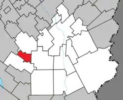 Location within Beauce-Sartigan RCM | |
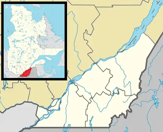 La Guadeloupe Location in southern Quebec | |
| Coordinates: 45°57′N 70°56′W / 45.95°N 70.93°W[1] | |
| Country | |
| Province | |
| Region | Chaudière-Appalaches |
| RCM | Beauce-Sartigan |
| Constituted | August 6, 1929 |
| Government | |
| • Mayor | Huguette Plante |
| • Federal riding | Beauce |
| • Prov. riding | Beauce-Sud |
| Area | |
| • Total | 32.70 km2 (12.63 sq mi) |
| • Land | 32.84 km2 (12.68 sq mi) |
| Population (2021)[3] | |
| • Total | 1,805 |
| • Density | 55/km2 (140/sq mi) |
| • Pop 2016-2021 | |
| • Dwellings | 860 |
| Time zone | UTC−5 (EST) |
| • Summer (DST) | UTC−4 (EDT) |
| Postal code(s) | |
| Area code(s) | 418 and 581 |
| Highways | |
| Census profile | [3] |
| MAMROT info | 29030[2] |
| Toponymie info | 33607[1] |
| Website | www |
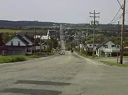
La Guadeloupe is a village in the Beauce-Sartigan Regional County Municipality in the Chaudière-Appalaches region of Quebec, Canada. Its population was 1,805 as of 2022.
Demographics
In the 2021 Census of Population conducted by Statistics Canada, La Guadeloupe had a population of 1,805 living in 814 of its 860 total private dwellings, an increase of 5.7% from its 2016 population of 1,707. With a land area of 32.84 km2 (12.68 sq mi), it had a population density of 55.0/km2 (142.4/sq mi) in 2021.[4]
Population
Population trend:[5]
| Census | Population | Change (%) |
|---|---|---|
| 2021 | 1,805 | |
| 2016 | 1,707 | |
| 2011 | 1,787 | |
| 2006 | 1,758 | |
| 2001 | 1,716 | |
| 1996 | 1,772 | |
| 1991 | 1,721 | |
| 1986 | 1,716 | |
| 1981 | 1,692 | |
| 1976 | 1,804 | |
| 1971 | 1,934 | |
| 1966 | 1,877 | |
| 1961 | 1,728 | |
| 1956 | 1,487 | |
| 1951 | 1,321 | |
| 1941 | 627 | |
| 1931 | 654 | N/A |
Language
Mother tongue language (2021)[6]
| Language | Population | Pct (%) |
|---|---|---|
| French only | 1,645 | 94.0% |
| English only | 5 | 0.3% |
| Both English and French | 10 | 0.6% |
| Other languages | 90 | 5.1% |
References
- 1 2 "Banque de noms de lieux du Québec: Reference number 33607". toponymie.gouv.qc.ca (in French). Commission de toponymie du Québec.
- 1 2 3 "Répertoire des municipalités: Geographic code 29030". www.mamh.gouv.qc.ca (in French). Ministère des Affaires municipales et de l'Habitation.
- 1 2 3 https://www12.statcan.gc.ca/census-recensement/2021/dp-pd/prof/details/page.cfm?Lang=E&SearchText=La%20guadeloupe&GENDERlist=1&STATISTIClist=1&DGUIDlist=2021A00052429030
- ↑ "Population and dwelling counts: Canada, provinces and territories, and census subdivisions (municipalities), Quebec". Statistics Canada. February 9, 2022. Retrieved August 28, 2022.
- ↑ Statistics Canada: 1996, 2001, 2006, 2011, 2016, 2021 census
- ↑ 2021 Statistics Canada Community Profile: La Guadeloupe, Quebec
External links
 Media related to La Guadeloupe at Wikimedia Commons
Places adjacent to La Guadeloupe | |
|---|---|
| Cities & Towns | |
|---|---|
| Municipalities | |
| Parishes | |
| Villages | |
| |
This article is issued from Wikipedia. The text is licensed under Creative Commons - Attribution - Sharealike. Additional terms may apply for the media files.