| Khan River | |
|---|---|
 | |
| Physical characteristics | |
| Source | Otjisemba, northwest of Okahandja |
| • location | Otjozondjupa Region |
| • coordinates | 22°42′S 14°54′E / 22.700°S 14.900°E |
| Mouth | Swakop River |
• location | c.40 kilometres (25 mi) east of Swakopmund |
| Basin size | 8,400 km2 (3,200 sq mi) |
| Basin features | |
| Tributaries | |
| • right | Slang River, Etiro River |
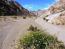
The river Khan is an ephemeral river crossing the Erongo region of central Namibia. It is the main tributary of the Swakop River[1] and only occasionally carries surface water during the rainy season from November to February/March. Khan's catchment area including its tributaries Slang and Etiro stretches over 8,400 square kilometres (3,200 sq mi).[2]
The Khan has its origin near the settlement of Otjisemba, north-west of Okahandja. From there the river course passes westwards to the town of Usakos, and further in a south-western direction through the Namib desert. It has its confluence with the Swakop River 40 km east of Swakopmund.[3]
It is a popular tourist attraction due to the proliferation of mammals such as the klipspringer antelope,[4] ostriches and jackals.
References
- ↑ "ELECTIONS 2010: Erongo regional profile". New Era. 16 November 2010. Archived from the original on 6 September 2012.
- ↑ Strohbach, B.J. (2008). "Mapping the Major Catchments of Namibia" (PDF 1.0MB). Agricola. 2008: 63–73. ISSN 1015-2334. OCLC 940637734.
- ↑ Jacobson, Peter J.; Jacobson, Kathryn M.; Seely, Mary K. (1995). Ephemeral rivers and their catchments: Sustaining people and development in western Namibia (PDF 8.7MB). Windhoek: Desert Research Foundation of Namibia. pp. 138–139. ISBN 9991670947.
- ↑ Stuart, C.T. (October 2019). "Preliminary notes on the mammals of the Namib Desert". Madoqua. 1975 (Series 2 Issue 4): 5–36. hdl:10520/AJA10115498_55.