| Kaw Mountain | |
|---|---|
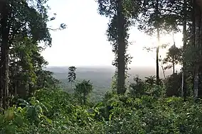 View from the mountain | |
| Highest point | |
| Elevation | 337 m (1,106 ft)[1] |
| Coordinates | 4°35′57″N 52°17′14″W / 4.5992°N 52.2872°W |
| Geography | |
 Kaw Mountain Location in French Guiana | |
| Location | Roura, French Guiana |
The Kaw Mountain is a 337 metres high mountain in the commune of Roura in French Guiana, France. It is a narrow tepui with a laterite top.[2]
Overview
Kaw Mountain is covered in rainforest and is part of the northern range of the Guiana Shield. The mountain is an obstacle to the trade winds leading to a very high humidity[3] resulting in an abundance of plant- and animal life.[4] The northern streams of the mountain flow into the Angélique Creek, the southern streams feed the Kaw and Mahury River.[3]
The mountain is located near the Kaw-Roura Marshland Nature Reserve.[5] On 12 February 2010, the General Council of French Guiana voted to protect the mountain and surrounding area as the Trésor Regional Nature Reserve.[6]
References
- ↑ "Carte IGN classique". Géoportail (in French). Retrieved 19 March 2021.
- ↑ Hilaire Annonay & Christian Feuillet (1997). "Passiflora Cerasina, A New Species of Passiflora Subgenus Passiflora (Passifloraceae) from French Guiana". SIDA, Contributions to Botany. 17 (3): 551–554. JSTOR 41967242.
- 1 2 "Montagnes de Kaw-Roura" (PDF). DEAL France (in French). Retrieved 19 March 2021.
- ↑ "Trésor". Reserves Naturelles (in French). Retrieved 19 March 2021.
- ↑ "Présentation". Réserve Trésor (in French). Retrieved 19 March 2021.
- ↑ "Délibération de création de la réserve" (PDF). Inventaire National du Patrimoine Naturel (in French). Retrieved 19 March 2021.
Wikimedia Commons has media related to Montagne de Kaw.
This article is issued from Wikipedia. The text is licensed under Creative Commons - Attribution - Sharealike. Additional terms may apply for the media files.