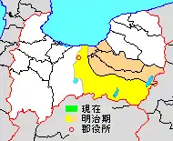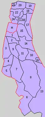
Map showing original extent of Kaminiikawa District in Toyama Prefecture:
* yellow - areas formerly within the district borders during the early Meiji period
* yellow - areas formerly within the district borders during the early Meiji period

Colored areas are in this district.
Kaminiikawa (上新川郡, Kaminiikawa-gun) was a district located in Toyama Prefecture, Japan.
As of 2003, the district had an estimated population of 34,491 with a density of 53.31 persons per km2. The total area was 646.98 km2.
Municipalities
Prior to its dissolution, the district consisted of only two towns:
- Notes
History
District Timeline
- 1889 (8 towns, 50 villages)
- At the time of enforcing the city status, the town of Toyama gained city status.
- At the time of enforcing the town and village status, the district formed into 8 towns and 49 villages.
- April 1, 1896 - 5 towns and 28 villages split and created Nakaniikawa District. (3 towns, 21 villages)
Recent mergers
- On April 1, 2005 - The towns of Ōsawano and Ōyama, along with the towns of Fuchū and Yatsuo, and the villages of Hosoiri and Yamada (all from Nei District), were merged into the expanded city of Toyama. Therefore, Kaminiikawa District and Nei District were dissolved as a result of this merger.
See also
This article is issued from Wikipedia. The text is licensed under Creative Commons - Attribution - Sharealike. Additional terms may apply for the media files.