Kahnuj County
Persian: شهرستان کهنوج | |
|---|---|
County | |
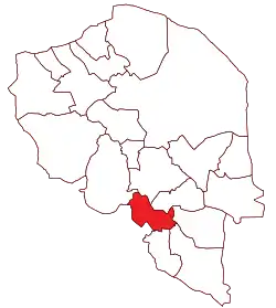 Location of Kahnuj County in Kerman province | |
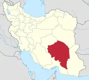 Location of Kerman province in Iran | |
| Coordinates: 27°54′N 57°40′E / 27.900°N 57.667°E[1] | |
| Country | |
| Province | Kerman |
| Capital | Kahnuj |
| Districts | Central, Chah Morid |
| Population (2016)[2] | |
| • Total | 95,848 |
| Time zone | UTC+3:30 (IRST) |
Kahnuj County (Persian: شهرستان کهنوج) is in Kerman province, Iran. Its capital is the city of Kahnuj.
At the 2006 census, the county's population was 102,269 in 21,780 households.[3] The following census in 2011 counted 86,290 people in 21,166 households,[4] by which time Faryab District had been separated from the county in the establishment of Faryab County,[5] and Deh Kahan Rural District of Manujan County had been transferred to the Central District.[6] At the 2016 census, the county's population was 95,848 in 26,276 households.[2] The majority of the people of Kahnuj are Baloch, and Balochi is the most widely spoken language.
Administrative divisions
The population history and structural changes of Kahnuj County's administrative divisions over three consecutive censuses are shown in the following table. The latest census shows two districts, five rural districts, and one city.[2]
After the 2016 census, the villages of Chah Morid and Deh Kahan were elevated to city status.[7]
| Administrative Divisions | 2006[3] | 2011[4] | 2016[2] |
|---|---|---|---|
| Central District | 70,664 | 75,064 | 84,603 |
| Deh Kahan RD1 | 7,980 | 7,397 | |
| Howmeh RD | 10,491 | ||
| Kutak RD | 8,768 | 8,320 | |
| Nakhlestan RD | 21,602 | 14,339 | 16,262 |
| Deh Kahan (city)2 | |||
| Kahnuj (city) | 38,571 | 43,977 | 52,624 |
| Chah Morid District | 11,226 | 11,245 | |
| Chah Rigan RD | 5,791 | 6,013 | |
| Howmeh RD | 5,435 | 5,232 | |
| Chah Morid (city)2 | |||
| Faryab District3 | 31,605 | ||
| Golashkerd RD | 5,353 | ||
| Hur RD | 14,920 | ||
| Mehruiyeh RD | 6,824 | ||
| Faryab (city) | 4,508 | ||
| Total | 102,269 | 86,290 | 95,848 |
| RD: Rural District 1Transferred from Manujan County[6] 2Became a city after the 2016 census[7] 3Became a part of Faryab County[5] | |||
References
- ↑ OpenStreetMap contributors (29 June 2023). "Kahnuj County" (Map). OpenStreetMap. Retrieved 29 June 2023.
- 1 2 3 4 "Census of the Islamic Republic of Iran, 1395 (2016)". AMAR (in Persian). The Statistical Center of Iran. p. 08. Archived from the original (Excel) on 20 October 2020. Retrieved 19 December 2022.
- 1 2 "Census of the Islamic Republic of Iran, 1385 (2006)". AMAR (in Persian). The Statistical Center of Iran. p. 08. Archived from the original (Excel) on 20 September 2011. Retrieved 25 September 2022.
- 1 2 "Census of the Islamic Republic of Iran, 1390 (2011)" (Excel). Iran Data Portal (in Persian). The Statistical Center of Iran. p. 08. Retrieved 19 December 2022.
- 1 2 "With six changes in the geography of Kerman province: Faryab County was added to the map of country divisions". DOLAT (in Persian). Ministry of Interior, Board of Ministers. 8 February 2011. Archived from the original on 22 January 2017. Retrieved 16 November 2023.
- 1 2 Rahimi, Mohammad Reza (7 July 2010). "The new city of Dusari was added to the map of country divisions". Fars News (in Persian). Ministry of Interior, Cabinet of Ministers. Archived from the original on 16 November 2023. Retrieved 16 November 2023.
- 1 2 "Inauguration of Chah Morid and Deh Kahan municipalities". Borna News (in Persian). Archived from the original on 29 June 2023. Retrieved 29 June 2023.
Kerman province, Iran | ||
|---|---|---|
| Capital | 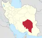 | |
| Counties and cities | ||
| Sights |
| |
| Places | ||