| Jewish Cemetery, Tarnogród | |
|---|---|
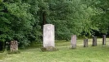
 General view in 2007 | |
| Details | |
| Established | 17th century |
| Location | |
| Country | Poland |
| Coordinates | 50°21′38″N 22°44′55″E / 50.36056°N 22.74861°E |
| Type | Jewish cemetery |
| Size | 1.8 ha |

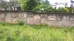
Fragment of matzevahs forming the wall of the present day cemetery
The Jewish Cemetery (Polish: Cmentarz Żydowski w Tarnogrodzie) in Tarnogród was probably established in 1588.[1] Located to the east of the synagogue, it covered an area of 1.8 hectares. During World War II, the Nazi Germans occupying Poland desacrated and destroyed the cemetery.[2] A few decades after the end of the war, from 1986 until 1990, the cemetery was renovated and partly surrounded by a wall to mark and protect it.[3] Around 100 pieces of recovered tombstones were placed within the area.[4] Some of the tombstones were embedded into the wall, becoming the so-called "commemoration wall". There is a monument to the memory of Poles of Jewish origin from Tarnogród who were murdered by the Germans in 1942.
Notes
- ↑ Burchard dates the cemetery back to the 18th century.
- ↑ "Tarnogród". Cmentarze żydowskie (in Polish and English). Retrieved 5 September 2022.
It functioned until 1942, when it was destroyed by Hitlerites [i.e. German Nazis] who used tombstones to create streets and backyards in Tarnogrod.
From the information board of the cemetery shown in the first picture on the left taken by Jolanta Dziubińska. - ↑ "Tarnogród". Cmentarze żydowskie (in Polish and English). Retrieved 5 September 2022.
... restored ... in 1989-1990. About 100 tombstones were regained. ... Regained macewas are built into the wall surrounding the cemetery.
In the Polish version it says additionally that the cemetery is partly surrounded by a wall (pol. "w części ogrodzony jest murem"). From the information board of the cemetery shown in the first picture on the left taken by Jolanta Dziubińska. - ↑ Burchard estimates that altogether roughly 1000 matzevahs from the cemetery have survived.
Bibliography
- Burchard, Przemysław (1990). Pamiątki i zabytki kultury żydowskiej w Polsce (in Polish). Warszawa: [s. n.] p. 177.
- A map of Leżajsk by the Polish Military Geographical Institute 47th strip 35th pole Warsaw of 1938.
External links
- The Jewish cemetery in Tarnogród in the Polish Virtual Shtetl site.
- Pictures of the cemetery in the Cmentarze żydowskie site (pl.)
This article is issued from Wikipedia. The text is licensed under Creative Commons - Attribution - Sharealike. Additional terms may apply for the media files.