Innere Stadt | |
|---|---|
1st city district of Graz | |
 | |
| Area | |
| • Total | 1.16 km2 (0.45 sq mi) |
| Population (2023) | |
| • Total | 3,314 |
| • Density | 2,900/km2 (7,400/sq mi) |
Innere Stadt (German pronunciation: [ˈɪnəʀə ʃtat] ⓘ
) is the 1st district of the Austrian city of Graz, capital of the federal state of Styria. It is the part of the Old Town (in German: Altstadt) containing the Schloßberg and the city park (Stadtpark). The district borders are formed by the river Mur between Radetzkybrücke and Keplerbrücke, the Wickenburggasse, the Glacis, Jakominiplatz and the Radetzkystraße.[1]
In 1999, the Old Town was declared a UNESCO World Heritage Site.
Cathedral of Graz
History
For the most part, the history of the Innere Stadt is the history of Graz.

View of world heritage site from the Kunsthaus: the Schloßberg on the left, the Old Town with the Franziskanerkirche on the right.
Points of interest
- Antoniuskirche
- Burg
- Deutschritterordenshaus
- Dom and Mausoleum
- Dreifaltigkeitskirche
- Franziskanerkirche
- Glockenspielplatz
- Hauptplatz
- Herrengasse
- Landhaus
- Landeszeughaus
- Murinsel
- Opernhaus
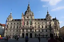
- Rathaus
- Sackstraße
- Schauspielhaus
- Schloßberg
- Sporgasse
- Stadtpark
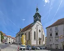
- Stadtpfarrkirche
- Universalmuseum Joanneum
References
- ↑ Service), Stadtportal der Landeshauptstadt Graz, Admin (Graz Press. "Zahlen + Fakten: Bevölkerung, Bezirke, Wirtschaft, Geografie". Stadtportal der Landeshauptstadt Graz (in German). Retrieved 2023-11-01.
{{cite web}}: CS1 maint: multiple names: authors list (link)
External links
Wikimedia Commons has media related to Graz Old Town.
- Website of the city of Graz (in German and English)
- UNESCO World Heritage Centre entry
47°4′19″N 15°26′27″E / 47.07194°N 15.44083°E
 | ||
This article is issued from Wikipedia. The text is licensed under Creative Commons - Attribution - Sharealike. Additional terms may apply for the media files.