Hopong | |
|---|---|
Town | |
 | |
 Hopong Location in Burma | |
| Coordinates: 20°47′0″N 97°11′0″E / 20.78333°N 97.18333°E | |
| Country | |
| State | |
| Districts | Taunggyi District |
| Township | Hopong Township |
| Elevation | 3,541 ft (1,079 m) |
| Population (2005) | |
| • Religions | Buddhism |
| Time zone | UTC+6.30 (MST) |
Look up ဝေင်ꩻဟိုပုံꩻ in Wiktionary, the free dictionary.
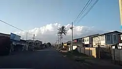
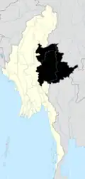
Hopong (Burmese: ဟိုပုန်းမြို့((Pa'o Karen: ဝေင်ꩻဟိုပုံꩻⓘ) is a town in the Shan State of eastern Burma. Hopong is the capital of Pa'O Self-Administered Zone. It is located in Hopong Township in Taunggyi District.
Hopong has some locally known places, like Htam Sam Cave and Mway Taw Pagoda.
External links
This article is issued from Wikipedia. The text is licensed under Creative Commons - Attribution - Sharealike. Additional terms may apply for the media files.

