 | ||||
|---|---|---|---|---|
| כביש 92 | ||||
 | ||||
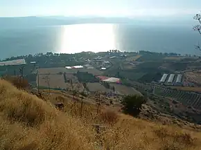 Highway 92 near Ein Gev | ||||
| Route information | ||||
| Length | 26 km (16 mi) | |||
| Major junctions | ||||
| South end | Samakh Junction | |||
| North end | Yehudiya Junction | |||
| Location | ||||
| Country | Israel | |||
| Highway system | ||||
| ||||
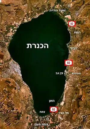
Highway 92 is a north-south highway in northeastern Israel. It follows the eastern edge of the Kinneret from Ma'agan junction in the south at Highway 98 to Yehudiya junction in the north at Highway 87. It is 24 km long.
Junctions & Interchanges (South to North)
| District[1] | Location[2] | km | mi | Name | Destinations | Notes |
|---|---|---|---|---|---|---|
| Northern | Samakh | 0 | 0.0 | צומת צמח (Samakh Junction) | ||
| Ma'agan | 1.5 | 0.93 | צומת מעגן (Ma'agan Junction) | |||
| Tel Katzir | 3.5 | 2.2 | צומת תל קציר (Tel Katzir Junction) | Entrance to Tel Katzir | ||
| HaOn | 5 | 3.1 | צומת האון (HaOn Junction) | Entrance to HaOn | ||
| Ein Gev | 12 | 7.5 | צומת עין גבר (Ein Gev Junction) | Entrance to Ein Gev | ||
| Kursi | 17 | 11 | צומת כורסי (Kursi Junction) | |||
| Ramot | 21 | 13 | צומת רמות (Ramot Junction) | Entrance to Ramot | ||
| Ma'ale Gamla | 23 | 14 | צומת מעלה גמלא (Ma'ale Gamla Junction) | |||
| Bethsaida Valley | 26 | 16 | צומת יהודיה (Yehudiya Junction) | |||
| 1.000 mi = 1.609 km; 1.000 km = 0.621 mi | ||||||
Places of interest near Highway 92
- Kibbutz HaOn
- Monument for Turkish soldiers
- Sussita archaeological site
- Kursi national park
- Luna-Gal beach
- Bethsaida, Bethsaida Valley and nature reserve
References
- ↑ Survey of Israel (October 31, 2018). "מחוזות משרד הפנים" [Ministry of Interior districts] (Map). Govmap (in Hebrew). Retrieved October 31, 2018.
- ↑ Survey of Israel (October 31, 2018). "גבולות ישובים" [Locality borders] (Map). Govmap (in Hebrew). Retrieved October 31, 2018.
See also
| Roads |
| ||||
|---|---|---|---|---|---|
| Bus operators | |||||
| Rail transport |
| ||||
| Cycling | |||||
| Sea ports | |||||
| Aviation |
| ||||
| Cable cars | |||||
| By city | |||||
| Smart cards | |||||
This article is issued from Wikipedia. The text is licensed under Creative Commons - Attribution - Sharealike. Additional terms may apply for the media files.