| Heathwood Brisbane, Queensland | |||||||||||||||
|---|---|---|---|---|---|---|---|---|---|---|---|---|---|---|---|
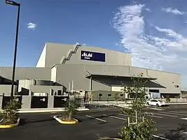
 Asahi Beverages in the industrial estate, 2017 | |||||||||||||||
 Heathwood | |||||||||||||||
| Coordinates | 27°38′28″S 152°59′26″E / 27.6411°S 152.9905°E | ||||||||||||||
| Population | 2,794 (2016 census)[1] | ||||||||||||||
| • Density | 559/km2 (1,447/sq mi) | ||||||||||||||
| Established | 1975 | ||||||||||||||
| Postcode(s) | 4110 | ||||||||||||||
| Area | 5.0 km2 (1.9 sq mi) | ||||||||||||||
| Time zone | AEST (UTC+10:00) | ||||||||||||||
| Location | 29.9 km (19 mi) SW of Brisbane GPO | ||||||||||||||
| LGA(s) | City of Brisbane (Calamvale Ward)[2] | ||||||||||||||
| State electorate(s) | |||||||||||||||
| Federal division(s) | Oxley | ||||||||||||||
| |||||||||||||||
Heathwood is an outer south-western suburb in the City of Brisbane, Queensland, Australia.[3] In the 2016 census, Heathwood had a population of 2,794 people.[1]
Geography
Heathwood is 29.9 kilometres (18.6 mi) by road southwest of the Brisbane GPO. It is relatively small in area but marked by brand new big houses.
The Logan Motorway passes through the suburb from west (Forest Lake) to east (Larapinta). It divides the suburb into two distinct areas, the northern part which is residential and the southern part which is industrial in the south and south-western parts and undeveloped in the south-eastern part.[4]
Heathwood is bounded to the north-east by Portree Crescent, Blunder Road, and Wadeville Street, to the south-west by Oxley Creek, to the south by Johnson Road, and to the west by Old Blunder Road.[4]
All the streets in Heathwood are named after native Australian flora/plants and trees.
History
The suburb was declared a suburb in 1970 when it was separated from Acacia Ridge. Heathwood was named after an early settler in the district.[3]
Demographics
In the 2011 census, Heathwood recorded a population of 1,820 people, 50.3% female and 49.7% male.[5] The median age of the Heathwood population was 32 years of age, 5 years below the Australian median. 54.2% of people living in Heathwood were born in Australia, compared to the national average of 69.8%; the next most common countries of birth were New Zealand 7.6%, Vietnam 5.5%, England 4.7%, India 3.2%, South Africa 2.5%. 63.3% of people spoke only English at home; the next most common languages were 9.1% Vietnamese, 3.6% Hindi, 2.5% Mandarin, 1.1% Sinhalese, 1.1% Samoan.[5]
In the 2016 census, Heathwood had a population of 2,794 people (an increase of 974 from the 2011 census).[1]
Education
There are no schools in Heathwood. The nearest primary school is Pallara State School in Pallara but on the boundary with Heathwood. The nearest secondary school is Forest Lake State High School in Forest Lake.[4]
Transport
Heathwood is connected to Brisbane CBD by a number of routes e.g. Centenary Highway through Forest Lake, Ipswich Motorway through Oxley, Logan Motorway and by rail through Richlands.
Transport for Brisbane operates two bus routes that serve stops in Heathwood:
- 118: to Brisbane City via Forest Lake and Logan Motorway[6][note 1]
- 460: to Brisbane City via Forest Lake Shops, Richlands Station and Indooroopilly[7]
References
- 1 2 3 Australian Bureau of Statistics (27 June 2017). "Heathwood (SSC)". 2016 Census QuickStats. Retrieved 20 October 2018.
- ↑ "Calamvale Ward". Brisbane City Council. Archived from the original on 4 February 2017. Retrieved 12 March 2017.
- 1 2 "Heathwood – suburb in City of Brisbane (entry 49682)". Queensland Place Names. Queensland Government. Retrieved 25 January 2020.
- 1 2 3 "Queensland Globe". State of Queensland. Retrieved 27 March 2020.
- 1 2 Australian Bureau of Statistics (31 October 2012). "Heathwood (State Suburb)". 2011 Census QuickStats. Retrieved 24 October 2013.
- ↑ "Route 118 timetable". Translink.
- ↑ "Route 460 timetable". Translink.
Notes
- ↑ Operates on weekday peak only in direction of peak.
External links
- "Pallara and Heathwood". Queensland Places. University of Queensland.