| Hardscrabble River | |
|---|---|
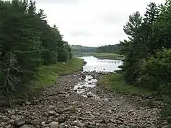 Hardscrabble River at head of tide, from U.S. Route 1 | |
| Location | |
| Country | United States |
| Physical characteristics | |
| Source | |
| • location | Maine |
| Mouth | |
• location | Dennys Bay |
• coordinates | 44°54′11″N 67°10′41″W / 44.903°N 67.178°W |
• elevation | sea level |
| Length | about 10 miles (16 km) |
Hardscrabble River is the estuary of Wilson Stream, a small river in Washington County, Maine. From its source (44°59′46″N 67°16′55″W / 44.996°N 67.282°W) in Charlotte, Wilson Stream runs about 10 miles (16 km) southeast to Dennys Bay. It changes name to Hardscrabble River at about the point where it is crossed by U.S. Route 1 (44°56′02″N 67°13′34″W / 44.9338°N 67.2261°W). This section of the stream separates Pembroke on its left bank from Dennysville and Edmunds on its right.
See also
References
- "Hardscrabble River". Geographic Names Information System. United States Geological Survey, United States Department of the Interior. 30 September 1980. Retrieved 2010-03-16.
- "Wilson Stream". Geographic Names Information System. United States Geological Survey, United States Department of the Interior. 30 September 1980. Retrieved 2010-03-16.
- Maine Streamflow Data from the USGS
- Maine Watershed Data From Environmental Protection Agency
This article is issued from Wikipedia. The text is licensed under Creative Commons - Attribution - Sharealike. Additional terms may apply for the media files.