 | |
| History | |
|---|---|
| Builder | Scotts, Greenock |
| Laid down | 5 October 1937 |
| Launched | 17 October 1939 |
| Commissioned | 8 March 1940 |
| Identification | Pennant number N17 |
| Fate | Sunk 14 April 1940[1] |
| Badge |  |
| General characteristics | |
| Class and type | British T class submarine |
| Displacement |
|
| Length | 275 ft (84 m) |
| Beam | 26 ft 6 in (8.08 m) |
| Draught | 16.3 ft (5.0 m) |
| Propulsion |
|
| Speed |
|
| Range | 4,500 nautical miles at 11 knots (8,330 km at 20 km/h) surfaced |
| Test depth | 300 ft (91 m) max |
| Complement | 59 |
| Armament |
|
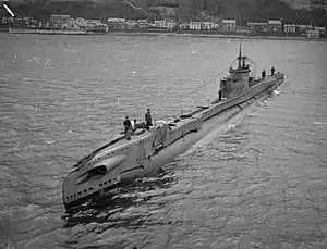
The second HMS Tarpon (N17) was a T-class submarine of the Royal Navy. She was laid down by Scotts, Greenock and launched in October 1939. She is named after the large fish Tarpon; one species of which is native to the Atlantic, and the other to the Indo-Pacific Oceans.[2]
Career
Tarpon had a short career, serving in the North Sea. She left Portsmouth on 5 April 1940 for Rosyth in company with HMS Severn. The following day they were ordered to Norway. On the 10th Tarpon was ordered to take up a new position. Tarpon was never heard from again.
It is asserted that there is a combination of British and German records which state that she was engaged by Schiff 40.[3] The records show that Tarpon had attacked the Q-ship Schiff 40/Schürbek, but her first torpedoes had missed. The Q-ship picked up the Tarpon on her sonar and her periscope was sighted. The ship dropped numerous depth charges in a sustained counterattack that went on most of the morning. Finally a pattern of depth charges brought wreckage to the surface. The Q-ship remained on the scene until 0500 the next morning when it became clear the submarine had been sunk. Tarpon was reported overdue on 22 April 1940.[4][5]
Wreck
The wreck was found and identified in the Danish part of the North Sea, near the harbour town of Thyborøn, by a Danish commercial diver, Gert Normann Andersen of the company JD-Contractor and British marine archaeologist Dr Innes McCartney in March 2016.[6][7] The wreck was explored in a live TV program by Denmark's Radio on 28 August 2016.[8] The submarine wreck was found with two torpedo tubes empty; confirming it likely they were fired in battle before her sinking. It is therefore still most likely she was then sunk by depth charges.[3] The wreck is submerged in 40 metres of water.[3]
Notes
- ↑ Colledge (2006), p. 344
- ↑ " Megalops atlanticus", www.fishbase.org, 11 February 2010.
- 1 2 3 "Sunken WWII-Era British Submarine Found off Danish Coast". New Historian. 10 September 2016. Retrieved 22 September 2016.
- ↑ HMS Tarpon, Uboat.net
- ↑ Submarine losses 1904 to present day Archived 8 August 2007 at the Wayback Machine, RN Submarine Museum, Gosport
- ↑ "Wreck of second world war British submarine found off Denmark". The Guardian. 5 September 2016. Retrieved 5 September 2016.
- ↑ Usædvanligt fund af ubåd fra anden verdenskrig fundet i dansk farvand, Jyllandsposten, 17 Marts 2016
- ↑ "Live fra dybet". Retrieved 5 September 2016.
References
- Akermann, Paul (2002). Encyclopaedia of British Submarines 1901–1955 (reprint of the 1989 ed.). Penzance, Cornwall: Periscope Publishing. ISBN 1-904381-05-7.
- Bagnasco, Erminio (1977). Submarines of World War Two. Annapolis, Maryland: Naval Institute Press. ISBN 0-87021-962-6.
- Colledge, J. J.; Warlow, Ben (2006) [1969]. Ships of the Royal Navy: The Complete Record of all Fighting Ships of the Royal Navy (Rev. ed.). London: Chatham Publishing. ISBN 978-1-86176-281-8.
- Chesneau, Roger, ed. (1980). Conway's All the World's Fighting Ships 1922–1946. Greenwich, UK: Conway Maritime Press. ISBN 0-85177-146-7.
- Kemp, Paul J. (1990). The T-class Submarine: The Classic British Design. Annapolis, Maryland: Naval Institute Press. ISBN 1-55750-826-7.
- McCartney, Innes (2006). British Submarines 1939–1945. New Vanguard. Vol. 129. Oxford, UK: Osprey. ISBN 1-84603-007-2.