H09 Hōsui-Susukino Station 豊水すすきの駅 | |||||||||||
|---|---|---|---|---|---|---|---|---|---|---|---|
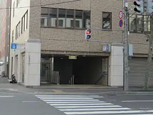 Station exit 6 | |||||||||||
| General information | |||||||||||
| Location | Chūō, Sapporo, Hokkaido Japan | ||||||||||
| Operated by | Sapporo City Transportation Bureau | ||||||||||
| Line(s) | |||||||||||
| Platforms | 1 island platform | ||||||||||
| Tracks | 2 | ||||||||||
| Construction | |||||||||||
| Accessible | Yes | ||||||||||
| Other information | |||||||||||
| Station code | H09 | ||||||||||
| History | |||||||||||
| Opened | December 2, 1988 | ||||||||||
| Services | |||||||||||
| |||||||||||
Hōsui-Susukino Station (豊水すすきの駅) is a Sapporo Municipal Subway in Chūō-ku, Sapporo, Hokkaido, Japan. The station number is H09.
The station is situated relatively close to Susukino on the Namboku Line and the Sapporo Streetcar, but there are no free transfers between the two stations.
The first retail store, a Lawson, was opened in the station on January 31, 2019,[1] after the station's Lawson kiosk was closed in July 2015.[2]
Platforms
| 1 | ■ Tōhō Line | for Fukuzumi |
| 2 | ■ Tōhō Line | for Sakaemachi |
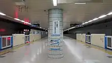
Station platform
Surrounding area
- Japan National Route 36, (to Muroran)
- Shinzenkoji (Jodo), Temple
- Chuokoji (Soto), Temple
- Tabata Hospital
- Susukino Central Police Station
- Minami San-jo Post Office
- Tanukikoji Shopping arcade
- Jasmac Plaza (Onsen Hotel)
- Susukino Green Hotel 1 & 3
- White Inn 6・2, Hotel
- APA Sapporo Suskino Hotel
- AOKI Bowling center
- Geo Dinos (Head office), amusement center
- VIVA Home store, Toyohira branch
- Sapporo Food Center store, Toyohira branch
- Aiba Central Sapporo satellite, (gambling center)
- North Pacific Bank, Susukino Chuo branch
- Hokkaido Bank, Susukino branch
- Tomakomai shinkin Bank, Sapporo branch
References
- ↑ "新店情報" (in Japanese). Lawson. Archived from the original on February 1, 2019.
- ↑ "「ローソン」、地下鉄東豊線豊水すすきの駅にも店舗" (in Japanese). リアルエコノミー. December 31, 2018. Archived from the original on August 24, 2019.
External links
Wikimedia Commons has media related to Hōsui-Susukino Station.
Stations of the Sapporo Municipal Subway Tōhō Line | ||
|---|---|---|
43°3′18.818″N 141°21′22.906″E / 43.05522722°N 141.35636278°E
This article is issued from Wikipedia. The text is licensed under Creative Commons - Attribution - Sharealike. Additional terms may apply for the media files.