Golpayegan County
Persian: شهرستان گلپایگان | |
|---|---|
County | |
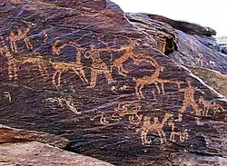
 Golpayegan petroglyphs | |
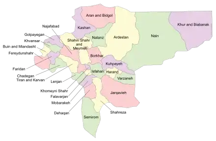
 Location of Golpayegan County in Isfahan province (top left, purple) | |
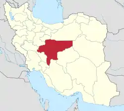
 Location of Isfahan province in Iran | |
| Coordinates: 33°26′N 50°21′E / 33.433°N 50.350°E[1] | |
| Country | |
| Province | Isfahan |
| Capital | Golpayegan |
| Districts | Central |
| Population (2016)[2] | |
| • Total | 90,086 |
| Time zone | UTC+3:30 (IRST) |
| Golpayegan County can be found at GEOnet Names Server, at this link, by opening the Advanced Search box, entering "9205998" in the "Unique Feature Id" form, and clicking on "Search Database". | |
Golpayegan County (Persian: شهرستان گلپایگان) is in Isfahan province, Iran. Its capital is the city of Golpayegan.
At the 2006 census, the county's population was 82,601 in 24,701 households.[3] The following census in 2011 counted 87,479 people in 28,190 households.[4] At the 2016 census, the county's population was 90,086 in 30,419 households.[2]
Administrative divisions
The population history of Golpayegan County's administrative divisions over three consecutive censuses is shown in the following table. The latest census shows one district, three rural districts, and three cities.[2]
| Administrative Divisions | 2006[3] | 2011[4] | 2016[2] |
|---|---|---|---|
| Central District | 82,601 | 87,479 | 90,082 |
| Jolgeh RD | 4,021 | 3,593 | 3,344 |
| Kenarrudkhaneh RD | 8,721 | 8,094 | 7,051 |
| Nivan RD | 5,358 | 5,309 | 4,835 |
| Golpayegan (city) | 47,849 | 54,572 | 58,936 |
| Golshahr (city) | 9,966 | 9,903 | 9,904 |
| Guged (city) | 6,686 | 6,008 | 6,012 |
| Total | 82,601 | 87,479 | 90,086 |
| RD: Rural District | |||
Earthquake of Golpayegan
The county's rural areas were devastated in the earthquake of 715 H/1316 AD [5] According to Mostawfi,[6] in 740 H/1339-40 AD Golpāyegān had some fifty villages, yielding the annual revenue of 42,000 dinars to the state, hinting that the city was very wealthy.
Location, climate and demography
Golpāyegān is located in Isfahan province, bordered on the south by the Bakhtiaris mountains and Khvansar County, on the east by the county of Barḵhar and Meyma, on the north by the counties of Mahallat and Khomein (Kamare), and on the west by Aligudarz county (province of Lorestān).
It comprises 3 rural districts (Jolge, Kenarruhkhune, nivuun) جلگه، کنار رودخونه، نیوون and 3 towns, namely, Gugad, Golshahr, and Golpāyegān. Persian: گوگد، گلشهر، گلپایگان
In 1237 H/1821-22 AD, Golpāyegān had some 2,000 households,[7] its population in 1324-25 H/1906-7 AD was 12,000 to 15,000. In 1996 AD the county had a population of 84,081 people, of whom 45,756 lived in urban areas [8]
Ghebla River
The most important river of Golpāyegān (Ghebla River), runs through the county, irrigating Khomein, Delijān, and Mahallat, before eventually emptying into the Gav ḵhuni salt swamp near Isfahan
Golpayegan Dam (Sade Golpayegan)
A dam Persian: سد گلپایگان 57 meter high has been constructed on this river at Aḵhteḵhun, located 18 km southeast of Golpāyegān .
Golpayegan's Dam, made by Engineer Aligholi Baiani[9] (مهندس علینقی بیانی), is the first modern dam in Iran. Irrigation in the area is by qanāt (in Persian:قنات / کاریز), well, and spring waters.
Agricultural products
Agricultural products include wheat, cotton, barley, grains, sugar, beets, and various kinds of fruits.
(apricots, apples, pears, cherries, cantaloupes, cucumbers, grapes, sour cherries, watermelons...)
Golpayegan has lot of Jeliz (in Persian: جیلیز Jeliz = Fruit and Vegetable Garden.[10]
Animal husbandry is also practiced. The region has stands of mountain-almond, (in Persian:بادام کوهی
wild fig, and barberry, as well as wild thyme, London rocket seed khak shir, milk-vetch,(in Persian:خاکشیر) bugloss, and gum-tragacanth plants.
The jackal, fox, wolf, and rabbit are among the wild animals found in the surrounding areas. There are also gold, silver, and gypsum deposits.
Golpayegan is famous (not only for Kabab, Kalle Pache (in Persian:کله پاچه) (sheep head, Khash), or Helium turkey...) is famous for its beautiful Persian rugs.
Handicrafts include carpet-weaving, giva (گیوه) cotton-shoe production, and wood-carving, Wood Sculpture, inlaid wood and embossed works.
References
- ↑ OpenStreetMap contributors (13 June 2023). "Golpayegan County" (Map). OpenStreetMap. Retrieved 13 June 2023.
- 1 2 3 4 "Census of the Islamic Republic of Iran, 1395 (2016)". AMAR (in Persian). The Statistical Center of Iran. p. 10. Archived from the original (Excel) on 19 October 2020. Retrieved 19 December 2022.
- 1 2 "Census of the Islamic Republic of Iran, 1385 (2006)". AMAR (in Persian). The Statistical Center of Iran. p. 10. Archived from the original (Excel) on 20 September 2011. Retrieved 25 September 2022.
- 1 2 "Census of the Islamic Republic of Iran, 1390 (2011)" (Excel). Iran Data Portal (in Persian). The Statistical Center of Iran. p. 10. Retrieved 19 December 2022.
- ↑ Nicholas N. Ambraseys and Charles P. Melville, A History of Persian Earthquakes, Cambridge, 1982; tr. A. Rada as Tāriḵ-e zamin-larzahā-ye Irān, Tehran, 1370 Š./1991
- ↑ (Nozhat al-qolub, ed. Le Strange, p. 68)
- ↑ ( Zayn-al-ʿĀbedin Eskandar Širvāni, Riāż al-siāḥa, Tehran, 1339 Š./1960, p. 707)
- ↑ (Markaz-e āmār ,1996, p. 10).
- ↑ سیمای فرزانگان – مهندس علیقلی بیانی، فرزانهای از جنس آب. علی اکبر جعفری . صدای گلپایگان
- ↑ The name of Jeliz (Jaliz) is in Shahnameh Ferdowsi. PALIZ
به پالیز بلبل بنالد همی
گل از ناله ٔ او ببالد همی
فردوسی
